

Wrach-Mänziwilegg-Häutligen-Wrach. 40km, 840hm
A cycling route starting in Wichtrach, Canton of Bern, Switzerland.
Overview
About this route
- 3 h 17 min
- Duration
- 37.8 km
- Distance
- 853 m
- Ascent
- 861 m
- Descent
- 11.5 km/h
- Avg. speed
- ---
- Max. altitude

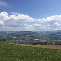
Route photos


Route quality
Waytypes & surfaces along the route
Waytypes
Quiet road
21.5 km
(57 %)
Road
11.3 km
(30 %)
Surfaces
Paved
16.6 km
(44 %)
Asphalt
15.5 km
(41 %)
Paved (undefined)
1.1 km
(3 %)
Undefined
21.1 km
(56 %)
Continue with Bikemap
Use, edit, or download this cycling route
You would like to ride Wrach-Mänziwilegg-Häutligen-Wrach. 40km, 840hm or customize it for your own trip? Here is what you can do with this Bikemap route:
Free features
- Save this route as favorite or in collections
- Copy & plan your own version of this route
- Sync your route with Garmin or Wahoo
Premium features
Free trial for 3 days, or one-time payment. More about Bikemap Premium.
- Navigate this route on iOS & Android
- Export a GPX / KML file of this route
- Create your custom printout (try it for free)
- Download this route for offline navigation
Discover more Premium features.
Get Bikemap PremiumFrom our community
Other popular routes starting in Wichtrach
 Wichtrach-Bleiken-Eggen-Heimenschwand-Linden-Oberdiessbach-Wichtrach
- Distance
- 30.5 km
- Ascent
- 962 m
- Descent
- 962 m
- Location
- Wichtrach, Canton of Bern, Switzerland
 Wrach-Belpberg-Gürbe-Seftigen-Stoffelsrüti-Limpachtal-Kirchdorf-Wrach, 37km
- Distance
- 33.9 km
- Ascent
- 493 m
- Descent
- 494 m
- Location
- Wichtrach, Canton of Bern, Switzerland
 Wrach-Ditligsee-Uetendorf-Wrach, 40km
- Distance
- 36 km
- Ascent
- 409 m
- Descent
- 412 m
- Location
- Wichtrach, Canton of Bern, Switzerland
 Wrach-Limpachtal-Uttigen-Wrach. 30km
- Distance
- 26.7 km
- Ascent
- 303 m
- Descent
- 307 m
- Location
- Wichtrach, Canton of Bern, Switzerland
 Wrach-Chutzen-Limpachtal-Uttigen-Wrach. 34km
- Distance
- 32.7 km
- Ascent
- 521 m
- Descent
- 538 m
- Location
- Wichtrach, Canton of Bern, Switzerland
 Wrach-Thun-Thierachern-Wrach. 35km, 300hm
- Distance
- 24.8 km
- Ascent
- 228 m
- Descent
- 221 m
- Location
- Wichtrach, Canton of Bern, Switzerland
 Wrach-Brenzikofen-Falkenfluh-Linden-Bärschwanden-Oberdiessbach-Wrach, 30km
- Distance
- 30.2 km
- Ascent
- 932 m
- Descent
- 919 m
- Location
- Wichtrach, Canton of Bern, Switzerland
 Wrach-Mänziwilegg-Häutligen-Wrach. 40km, 840hm
- Distance
- 37.8 km
- Ascent
- 853 m
- Descent
- 861 m
- Location
- Wichtrach, Canton of Bern, Switzerland
Open it in the app