

Begleitung ERT 2008
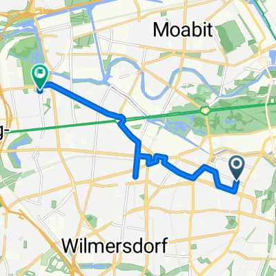
A cycling route starting in Tiergarten, State of Berlin, Germany.
Overview
About this route
Participation in the 'Europa-Radtour' to Dobbrikow, from there return to Berlin. From Dobbrikow to Zülichendorf, an extremely quiet route, a bit more traffic up to the B2. There is a good cycle path next to the road (but there wasn't much going on the road either). The route to Borkheide is almost completely car-free and the R1 cycle path to Ferch is a delight; in Beelitz Heilstätten, the R1 towards Potsdam is a bit hard to find - it starts, without signage, a few hundred meters towards Beelitz and then leads pleasantly undulating until just before Ferch.
- -:--
- Duration
- 148.2 km
- Distance
- 358 m
- Ascent
- 350 m
- Descent
- ---
- Avg. speed
- 85 m
- Max. altitude

Route quality
Waytypes & surfaces along the route
Waytypes
Road
34.1 km
(23 %)
Quiet road
19.3 km
(13 %)
Surfaces
Paved
127.5 km
(86 %)
Unpaved
5.9 km
(4 %)
Asphalt
126 km
(85 %)
Concrete
1.5 km
(1 %)
Continue with Bikemap
Use, edit, or download this cycling route
You would like to ride Begleitung ERT 2008 or customize it for your own trip? Here is what you can do with this Bikemap route:
Free features
- Save this route as favorite or in collections
- Copy & plan your own version of this route
- Split it into stages to create a multi-day tour
- Sync your route with Garmin or Wahoo
Premium features
Free trial for 3 days, or one-time payment. More about Bikemap Premium.
- Navigate this route on iOS & Android
- Export a GPX / KML file of this route
- Create your custom printout (try it for free)
- Download this route for offline navigation
Discover more Premium features.
Get Bikemap PremiumFrom our community
Other popular routes starting in Tiergarten
 Seddiner See
- Distance
- 115.4 km
- Ascent
- 229 m
- Descent
- 229 m
- Location
- Tiergarten, State of Berlin, Germany
 Skoda Velothon 2011 60km
- Distance
- 63.9 km
- Ascent
- 0 m
- Descent
- 0 m
- Location
- Tiergarten, State of Berlin, Germany
 2021 Spreewald Tag 7: Radrundtour Berlin, 16 km
- Distance
- 15.6 km
- Ascent
- 75 m
- Descent
- 72 m
- Location
- Tiergarten, State of Berlin, Germany
 Begleitung ERT 2008
- Distance
- 148.2 km
- Ascent
- 358 m
- Descent
- 350 m
- Location
- Tiergarten, State of Berlin, Germany
 Wannsee round
- Distance
- 70.4 km
- Ascent
- 288 m
- Descent
- 291 m
- Location
- Tiergarten, State of Berlin, Germany
 Stadtführung Berlin, Rundgang oder Radtour durch den Westen von www.stadtspiele-verlag.de
- Distance
- 7.4 km
- Ascent
- 54 m
- Descent
- 54 m
- Location
- Tiergarten, State of Berlin, Germany
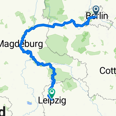 Von Berlin bis Leipzig
- Distance
- 364.5 km
- Ascent
- 1,140 m
- Descent
- 1,041 m
- Location
- Tiergarten, State of Berlin, Germany
 Feierabendrunde Berlin-NordWest
- Distance
- 63.6 km
- Ascent
- 107 m
- Descent
- 98 m
- Location
- Tiergarten, State of Berlin, Germany
Open it in the app