

Lake Michigan Loop
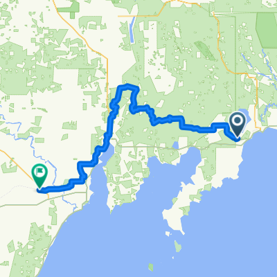
Day 6: Mantistique > Menominee
A cycling route starting in Manistique, Michigan, United States.
Overview
About this route
Day 6 of the Lake Michigan Send
- -:--
- Duration
- 171.4 km
- Distance
- 149 m
- Ascent
- 141 m
- Descent
- ---
- Avg. speed
- ---
- Max. altitude

Part of
Lake Michigan Loop
11 stages
Continue with Bikemap
Use, edit, or download this cycling route
You would like to ride Day 6: Mantistique > Menominee or customize it for your own trip? Here is what you can do with this Bikemap route:
Free features
- Save this route as favorite or in collections
- Copy & plan your own version of this route
- Split it into stages to create a multi-day tour
- Sync your route with Garmin or Wahoo
Premium features
Free trial for 3 days, or one-time payment. More about Bikemap Premium.
- Navigate this route on iOS & Android
- Export a GPX / KML file of this route
- Create your custom printout (try it for free)
- Download this route for offline navigation
Discover more Premium features.
Get Bikemap PremiumFrom our community
Other popular routes starting in Manistique
 Manistique to St. Ignace
- Distance
- 139.6 km
- Ascent
- 243 m
- Descent
- 207 m
- Location
- Manistique, Michigan, United States
 Manistique to Manistique
- Distance
- 1.7 km
- Ascent
- 9 m
- Descent
- 6 m
- Location
- Manistique, Michigan, United States
 935N River Rd, Manistique to 935N River Rd, Manistique
- Distance
- 11.7 km
- Ascent
- 69 m
- Descent
- 62 m
- Location
- Manistique, Michigan, United States
 Manistique to Manistique
- Distance
- 14.4 km
- Ascent
- 59 m
- Descent
- 59 m
- Location
- Manistique, Michigan, United States
 794N Thunder Lake Rd, Manistique to Peterson Rd, Manistique
- Distance
- 4 km
- Ascent
- 7 m
- Descent
- 4 m
- Location
- Manistique, Michigan, United States
 Recovered Route
- Distance
- 5.9 km
- Ascent
- 41 m
- Descent
- 57 m
- Location
- Manistique, Michigan, United States
 935N River Rd, Manistique to 935N River Rd, Manistique
- Distance
- 11 km
- Ascent
- 45 m
- Descent
- 58 m
- Location
- Manistique, Michigan, United States
 Manistique - Escanaba
- Distance
- 141.7 km
- Ascent
- 583 m
- Descent
- 556 m
- Location
- Manistique, Michigan, United States
Open it in the app