

MontBlancTour2Tag
A cycling route starting in San Leonardo, Aosta Valley, Italy.
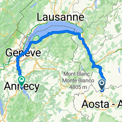
Overview
About this route
Second day of the Mont Blanc tour by MTB
- -:--
- Duration
- 40.5 km
- Distance
- 2,242 m
- Ascent
- 2,425 m
- Descent
- ---
- Avg. speed
- ---
- Max. altitude
Continue with Bikemap
Use, edit, or download this cycling route
You would like to ride MontBlancTour2Tag or customize it for your own trip? Here is what you can do with this Bikemap route:
Free features
- Save this route as favorite or in collections
- Copy & plan your own version of this route
- Sync your route with Garmin or Wahoo
Premium features
Free trial for 3 days, or one-time payment. More about Bikemap Premium.
- Navigate this route on iOS & Android
- Export a GPX / KML file of this route
- Create your custom printout (try it for free)
- Download this route for offline navigation
Discover more Premium features.
Get Bikemap PremiumFrom our community
Other popular routes starting in San Leonardo
 2010_Franki 01 GBernard_Chatillon
- Distance
- 73.8 km
- Ascent
- 391 m
- Descent
- 2,360 m
- Location
- San Leonardo, Aosta Valley, Italy
 MontBlancTour2Tag
- Distance
- 40.5 km
- Ascent
- 2,242 m
- Descent
- 2,425 m
- Location
- San Leonardo, Aosta Valley, Italy
 Tour du Mont Blanc Etape 3
- Distance
- 135.3 km
- Ascent
- 1,868 m
- Descent
- 3,444 m
- Location
- San Leonardo, Aosta Valley, Italy
 TMB 3
TMB 3- Distance
- 22.6 km
- Ascent
- 1,199 m
- Descent
- 1,306 m
- Location
- San Leonardo, Aosta Valley, Italy
 giro dei 3 colli
- Distance
- 11.6 km
- Ascent
- 896 m
- Descent
- 902 m
- Location
- San Leonardo, Aosta Valley, Italy
 Tunnel du Grand Saint-Bernard, Bourg-St-Pierre to Esplanade de l'Hôtel de Ville, Annecy
- Distance
- 221.7 km
- Ascent
- 3,862 m
- Descent
- 5,885 m
- Location
- San Leonardo, Aosta Valley, Italy
 włoski wypad cz.2
- Distance
- 501.4 km
- Ascent
- 2,775 m
- Descent
- 3,232 m
- Location
- San Leonardo, Aosta Valley, Italy
 2010_Frankovska_pot_2010
- Distance
- 866.7 km
- Ascent
- 2,312 m
- Descent
- 4,735 m
- Location
- San Leonardo, Aosta Valley, Italy
Open it in the app