

MontBlancTour5Tag
A cycling route starting in Martigny-Combe, Valais, Switzerland.
Overview
About this route
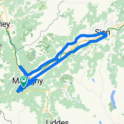
Fifth day of the Mont Blanc circuit on the MTB
- -:--
- Duration
- 14 km
- Distance
- 1,107 m
- Ascent
- 935 m
- Descent
- ---
- Avg. speed
- ---
- Max. altitude
Continue with Bikemap
Use, edit, or download this cycling route
You would like to ride MontBlancTour5Tag or customize it for your own trip? Here is what you can do with this Bikemap route:
Free features
- Save this route as favorite or in collections
- Copy & plan your own version of this route
- Sync your route with Garmin or Wahoo
Premium features
Free trial for 3 days, or one-time payment. More about Bikemap Premium.
- Navigate this route on iOS & Android
- Export a GPX / KML file of this route
- Create your custom printout (try it for free)
- Download this route for offline navigation
Discover more Premium features.
Get Bikemap PremiumFrom our community
Other popular routes starting in Martigny-Combe
 La Chatelard-Lac de Emosson
- Distance
- 18.3 km
- Ascent
- 1,556 m
- Descent
- 838 m
- Location
- Martigny-Combe, Valais, Switzerland
 Trevor Base Route
- Distance
- 93.3 km
- Ascent
- 715 m
- Descent
- 715 m
- Location
- Martigny-Combe, Valais, Switzerland
 Champex and Val Ferret
- Distance
- 62.9 km
- Ascent
- 1,722 m
- Descent
- 1,722 m
- Location
- Martigny-Combe, Valais, Switzerland
 Hiking 120 Miles Alone on the Tour Du Mont Blanc Loop
- Distance
- 165.3 km
- Ascent
- 12,832 m
- Descent
- 12,837 m
- Location
- Martigny-Combe, Valais, Switzerland
 MontBlancTour5Tag
- Distance
- 14 km
- Ascent
- 1,107 m
- Descent
- 935 m
- Location
- Martigny-Combe, Valais, Switzerland
 Trevor - Champex and Planche
- Distance
- 51.3 km
- Ascent
- 1,740 m
- Descent
- 1,740 m
- Location
- Martigny-Combe, Valais, Switzerland
 VTT MONT BLANC Vllorcine Albertville
- Distance
- 432.8 km
- Ascent
- 8,172 m
- Descent
- 8,462 m
- Location
- Martigny-Combe, Valais, Switzerland
 Trevor - Champex lac loop
- Distance
- 42.5 km
- Ascent
- 1,099 m
- Descent
- 1,099 m
- Location
- Martigny-Combe, Valais, Switzerland
Open it in the app