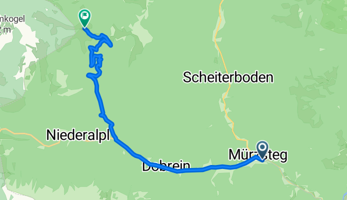
BergRadlTour auf die Dürrieglalm im Naturpark Mürzer Oberland
A cycling route starting in Mürzsteg, Styria, Austria.
Overview
About this route
Wir starten die Tour direkt in Mürzsteg und fahren auf der Bundesstraße durch den Ortsteil Dobrein bis zur Abzweigung in den Gschwandgraben auf der rechten Seite. Von dort folgen wir weiter dem Wegverlauf in den Buchalpengraben und weiter auf die 1253 m hoch gelegene Dürrieglalm. Hier gibt es die Möglichkeit direkt an die Alpentour in Mariazell anzuschließen oder auf derselben Strecke wieder zum Ausgangspunkt zurückzufahren.
- -:--
- Duration
- 12 km
- Distance
- 675 m
- Ascent
- 103 m
- Descent
- ---
- Avg. speed
- ---
- Avg. speed
Route quality
Waytypes & surfaces along the route
Waytypes
Track
6.9 km
(58 %)
Busy road
4.7 km
(39 %)
Surfaces
Paved
5.3 km
(44 %)
Unpaved
0.8 km
(7 %)
Asphalt
4.7 km
(39 %)
Gravel
0.8 km
(7 %)
Continue with Bikemap
Use, edit, or download this cycling route
You would like to ride BergRadlTour auf die Dürrieglalm im Naturpark Mürzer Oberland or customize it for your own trip? Here is what you can do with this Bikemap route:
Free features
- Save this route as favorite or in collections
- Copy & plan your own version of this route
- Sync your route with Garmin or Wahoo
Premium features
Free trial for 3 days, or one-time payment. More about Bikemap Premium.
- Navigate this route on iOS & Android
- Export a GPX / KML file of this route
- Create your custom printout (try it for free)
- Download this route for offline navigation
Discover more Premium features.
Get Bikemap PremiumFrom our community
Other popular routes starting in Mürzsteg
- BergRadlTour auf die Dürrieglalm im Naturpark Mürzer Oberland
- Distance
- 12 km
- Ascent
- 675 m
- Descent
- 103 m
- Location
- Mürzsteg, Styria, Austria
- mürzsteg-retteneg
- Distance
- 129.7 km
- Ascent
- 1,660 m
- Descent
- 1,660 m
- Location
- Mürzsteg, Styria, Austria
- BergRadlRunde über die Mürzsteger Almen im Naturpark Mürzer Oberland
- Distance
- 32.2 km
- Ascent
- 1,030 m
- Descent
- 1,030 m
- Location
- Mürzsteg, Styria, Austria
- R5 Mürztalradweg
- Distance
- 68.4 km
- Ascent
- 560 m
- Descent
- 854 m
- Location
- Mürzsteg, Styria, Austria
- Mürzsteg - Kapfenberg
- Distance
- 121.7 km
- Ascent
- 1,194 m
- Descent
- 1,194 m
- Location
- Mürzsteg, Styria, Austria
- R5 Mürztalradweg
- Distance
- 68.4 km
- Ascent
- 234 m
- Descent
- 533 m
- Location
- Mürzsteg, Styria, Austria
- Mariazell04
- Distance
- 98.6 km
- Ascent
- 1,337 m
- Descent
- 1,344 m
- Location
- Mürzsteg, Styria, Austria
- Mit dem E Bike auf das Preiner Gscheid im Naturpark Mürzer Oberland
- Distance
- 47.5 km
- Ascent
- 878 m
- Descent
- 875 m
- Location
- Mürzsteg, Styria, Austria
Open it in the app