

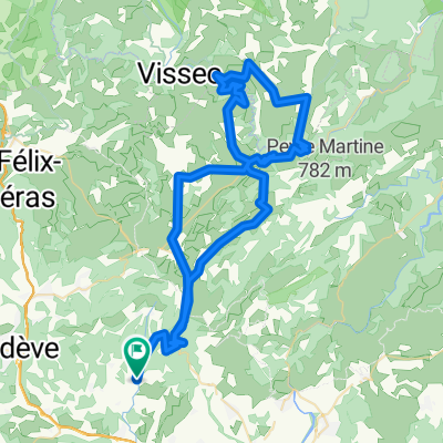
GTH 07. Arboras Le Caylar retour 72km
A cycling route starting in Montpeyroux, Occitanie, France.
Overview
About this route
- -:--
- Duration
- 73.8 km
- Distance
- 971 m
- Ascent
- 954 m
- Descent
- ---
- Avg. speed
- ---
- Max. altitude

Route quality
Waytypes & surfaces along the route
Waytypes
Track
25.8 km
(35 %)
Road
12.5 km
(17 %)
Surfaces
Paved
39.1 km
(53 %)
Unpaved
22.1 km
(30 %)
Asphalt
36.9 km
(50 %)
Gravel
16.2 km
(22 %)
Continue with Bikemap
Use, edit, or download this cycling route
You would like to ride GTH 07. Arboras Le Caylar retour 72km or customize it for your own trip? Here is what you can do with this Bikemap route:
Free features
- Save this route as favorite or in collections
- Copy & plan your own version of this route
- Sync your route with Garmin or Wahoo
Premium features
Free trial for 3 days, or one-time payment. More about Bikemap Premium.
- Navigate this route on iOS & Android
- Export a GPX / KML file of this route
- Create your custom printout (try it for free)
- Download this route for offline navigation
Discover more Premium features.
Get Bikemap PremiumFrom our community
Other popular routes starting in Montpeyroux
 La Bueges
- Distance
- 54.3 km
- Ascent
- 783 m
- Descent
- 783 m
- Location
- Montpeyroux, Occitanie, France
 GIGNAC CIRQUE VISSEC
- Distance
- 93.7 km
- Ascent
- 1,472 m
- Descent
- 1,461 m
- Location
- Montpeyroux, Occitanie, France
 Montpeyroux - Circle through Gorges-de-l'Hérault and St-Jean-de-Buèges
- Distance
- 51.4 km
- Ascent
- 969 m
- Descent
- 979 m
- Location
- Montpeyroux, Occitanie, France
 MUC Cyclo-Portée du 4 juin 2014
- Distance
- 68.1 km
- Ascent
- 987 m
- Descent
- 987 m
- Location
- Montpeyroux, Occitanie, France
![[Terres Rouges] Descenso du Ruffles. ¡Espectacular!](https://media.bikemap.net/routes/11495871/staticmaps/in_3abb83c1-d439-45c9-aa9d-eb66077f5791_400x400_bikemap-2021-3D-static.png) [Terres Rouges] Descenso du Ruffles. ¡Espectacular!
[Terres Rouges] Descenso du Ruffles. ¡Espectacular!- Distance
- 22.2 km
- Ascent
- 1,136 m
- Descent
- 1,139 m
- Location
- Montpeyroux, Occitanie, France
 Cirque Navacelles 2
- Distance
- 89.5 km
- Ascent
- 1,540 m
- Descent
- 1,543 m
- Location
- Montpeyroux, Occitanie, France
 GTH 07. Arboras Le Caylar retour 72km
- Distance
- 73.8 km
- Ascent
- 971 m
- Descent
- 954 m
- Location
- Montpeyroux, Occitanie, France
 ASCENSO AL MONT-SAINT-BAUDILLE
- Distance
- 3.2 km
- Ascent
- 169 m
- Descent
- 39 m
- Location
- Montpeyroux, Occitanie, France
Open it in the app