

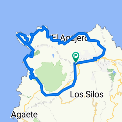
Paseo por el Noroeste
A cycling route starting in Gáldar, Canary Islands, Spain.
Overview
About this route
Mixed route of dirt and asphalt passing along the coast, north, Sardina lighthouse ...
- -:--
- Duration
- 26.9 km
- Distance
- 419 m
- Ascent
- 419 m
- Descent
- ---
- Avg. speed
- ---
- Max. altitude

Route highlights
Points of interest along the route
Point of interest after 6.1 km
Primera parada
Point of interest after 14.1 km
Segunda parada
Point of interest after 19.4 km
Tercera parada
Continue with Bikemap
Use, edit, or download this cycling route
You would like to ride Paseo por el Noroeste or customize it for your own trip? Here is what you can do with this Bikemap route:
Free features
- Save this route as favorite or in collections
- Copy & plan your own version of this route
- Sync your route with Garmin or Wahoo
Premium features
Free trial for 3 days, or one-time payment. More about Bikemap Premium.
- Navigate this route on iOS & Android
- Export a GPX / KML file of this route
- Create your custom printout (try it for free)
- Download this route for offline navigation
Discover more Premium features.
Get Bikemap PremiumFrom our community
Other popular routes starting in Gáldar
 Gáldar-La Atalaya-Sardina-Hoya Pineda-Marmolejo-Gáldar
- Distance
- 29.8 km
- Ascent
- 480 m
- Descent
- 480 m
- Location
- Gáldar, Canary Islands, Spain
 12-07- Costa Norte por Galdar y Sardina
- Distance
- 32.5 km
- Ascent
- 495 m
- Descent
- 495 m
- Location
- Gáldar, Canary Islands, Spain
 GALDAR-ARTENARA-AGAETE-GALDAR
- Distance
- 77.2 km
- Ascent
- 1,740 m
- Descent
- 1,742 m
- Location
- Gáldar, Canary Islands, Spain
 agujero punta de galdar botija y barranco de galdar
- Distance
- 23 km
- Ascent
- 403 m
- Descent
- 403 m
- Location
- Gáldar, Canary Islands, Spain
 Paseo por el Noroeste
- Distance
- 26.9 km
- Ascent
- 419 m
- Descent
- 419 m
- Location
- Gáldar, Canary Islands, Spain
 Municipal Guía
- Distance
- 12.9 km
- Ascent
- 411 m
- Descent
- 258 m
- Location
- Gáldar, Canary Islands, Spain
 Sardina del Norte
- Distance
- 54.7 km
- Ascent
- 705 m
- Descent
- 709 m
- Location
- Gáldar, Canary Islands, Spain
 13.08.15
- Distance
- 51.9 km
- Ascent
- 1,204 m
- Descent
- 1,201 m
- Location
- Gáldar, Canary Islands, Spain
Open it in the app