

trasa-8
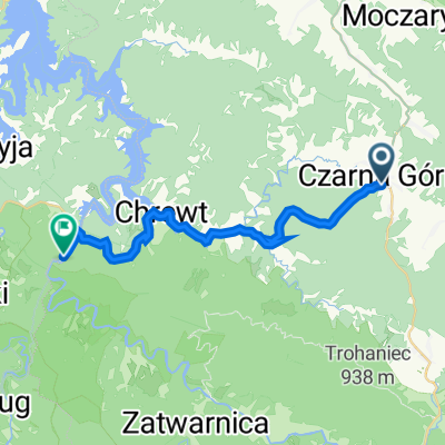
A cycling route starting in Czarna, Subcarpathian Voivodeship, Poland.
Overview
About this route
Polana Polana Ostre Skorodne Lutowiska, parking on hill 723, Mount Bogdanów (variant; Lutowiska) film road on the northern slope of Otryt Wańka Dział Polana
- -:--
- Duration
- 30.9 km
- Distance
- 396 m
- Ascent
- 396 m
- Descent
- ---
- Avg. speed
- ---
- Max. altitude

Route quality
Waytypes & surfaces along the route
Waytypes
Track
17 km
(55 %)
Quiet road
8.7 km
(28 %)
Surfaces
Paved
13 km
(42 %)
Unpaved
14.2 km
(46 %)
Paved (undefined)
9 km
(29 %)
Gravel
9 km
(29 %)
Continue with Bikemap
Use, edit, or download this cycling route
You would like to ride trasa-8 or customize it for your own trip? Here is what you can do with this Bikemap route:
Free features
- Save this route as favorite or in collections
- Copy & plan your own version of this route
- Sync your route with Garmin or Wahoo
Premium features
Free trial for 3 days, or one-time payment. More about Bikemap Premium.
- Navigate this route on iOS & Android
- Export a GPX / KML file of this route
- Create your custom printout (try it for free)
- Download this route for offline navigation
Discover more Premium features.
Get Bikemap PremiumFrom our community
Other popular routes starting in Czarna
 Górami 18,5 km (Dolny Koniec - Lutowiska)
- Distance
- 31.6 km
- Ascent
- 466 m
- Descent
- 465 m
- Location
- Czarna, Subcarpathian Voivodeship, Poland
 Chrewt 4
- Distance
- 36.4 km
- Ascent
- 595 m
- Descent
- 592 m
- Location
- Czarna, Subcarpathian Voivodeship, Poland
 Lesko_U_Janusza
- Distance
- 70.9 km
- Ascent
- 739 m
- Descent
- 944 m
- Location
- Czarna, Subcarpathian Voivodeship, Poland
 CZarna Góra - CIsna
- Distance
- 63.8 km
- Ascent
- 788 m
- Descent
- 823 m
- Location
- Czarna, Subcarpathian Voivodeship, Poland
 EDEN - Czarna Góra - EDEN
- Distance
- 21.4 km
- Ascent
- 376 m
- Descent
- 489 m
- Location
- Czarna, Subcarpathian Voivodeship, Poland
 Dookoła pensjonatu Rabe
- Distance
- 5.1 km
- Ascent
- 175 m
- Descent
- 170 m
- Location
- Czarna, Subcarpathian Voivodeship, Poland
 Chrewt 2
- Distance
- 30.7 km
- Ascent
- 547 m
- Descent
- 547 m
- Location
- Czarna, Subcarpathian Voivodeship, Poland
 Chrewt 1
- Distance
- 17.3 km
- Ascent
- 305 m
- Descent
- 307 m
- Location
- Czarna, Subcarpathian Voivodeship, Poland
Open it in the app