

Ax-les-Thermes - Sispony
A cycling route starting in Ax-les-Thermes, Occitanie, France.
Overview
About this route
Pyrenäentour 2005
- -:--
- Duration
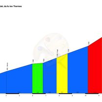
- 102.3 km
- Distance
- 3,291 m
- Ascent
- 2,476 m
- Descent
- ---
- Avg. speed
- 2,407 m
- Max. altitude
Route quality
Waytypes & surfaces along the route
Waytypes
Cycleway
3.1 km
(3 %)
Access road
2 km
(2 %)
Surfaces
Paved
88 km
(86 %)
Unpaved
1 km
(1 %)
Asphalt
88 km
(86 %)
Gravel
1 km
(1 %)
Undefined
13.3 km
(13 %)
Continue with Bikemap
Use, edit, or download this cycling route
You would like to ride Ax-les-Thermes - Sispony or customize it for your own trip? Here is what you can do with this Bikemap route:
Free features
- Save this route as favorite or in collections
- Copy & plan your own version of this route
- Split it into stages to create a multi-day tour
- Sync your route with Garmin or Wahoo
Premium features
Free trial for 3 days, or one-time payment. More about Bikemap Premium.
- Navigate this route on iOS & Android
- Export a GPX / KML file of this route
- Create your custom printout (try it for free)
- Download this route for offline navigation
Discover more Premium features.
Get Bikemap PremiumFrom our community
Other popular routes starting in Ax-les-Thermes
 Pradel, Pailheres y Ax 3 Domaines
- Distance
- 95.6 km
- Ascent
- 0 m
- Descent
- 0 m
- Location
- Ax-les-Thermes, Occitanie, France
 AX 3 DOMAINES - PLATEAU DE BEILLE
- Distance
- 81.4 km
- Ascent
- 2,111 m
- Descent
- 2,110 m
- Location
- Ax-les-Thermes, Occitanie, France
 Ax-les-Thermes 2
- Distance
- 108.6 km
- Ascent
- 2,793 m
- Descent
- 2,790 m
- Location
- Ax-les-Thermes, Occitanie, France
 Port de Pailheres
- Distance
- 37.9 km
- Ascent
- 1,291 m
- Descent
- 1,290 m
- Location
- Ax-les-Thermes, Occitanie, France
 2) Ax-Les-Thermes Route 3
- Distance
- 81.7 km
- Ascent
- 2,412 m
- Descent
- 2,413 m
- Location
- Ax-les-Thermes, Occitanie, France
 Pyrénées- Andorre- Espagne- Barcelone
- Distance
- 289.7 km
- Ascent
- 3,844 m
- Descent
- 4,484 m
- Location
- Ax-les-Thermes, Occitanie, France
 Ax-les-Thermes - Col Ascou Palhières - Col du pradel - Ax Bonascre
- Distance
- 74.8 km
- Ascent
- 2,432 m
- Descent
- 2,433 m
- Location
- Ax-les-Thermes, Occitanie, France
 2012 T6
- Distance
- 169.8 km
- Ascent
- 1,579 m
- Descent
- 2,300 m
- Location
- Ax-les-Thermes, Occitanie, France
Open it in the app