

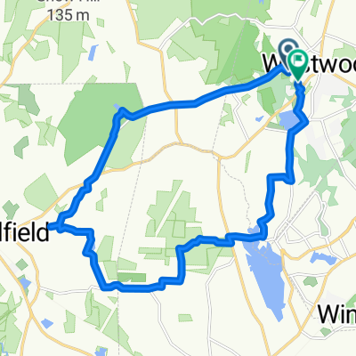
25 mile loop needham/dover
A cycling route starting in Westwood, Massachusetts, United States.
Overview
About this route
- -:--
- Duration
- 39.5 km
- Distance
- 213 m
- Ascent
- 212 m
- Descent
- ---
- Avg. speed
- ---
- Max. altitude

Route quality
Waytypes & surfaces along the route
Waytypes
Road
19 km
(48 %)
Quiet road
9.1 km
(23 %)
Surfaces
Paved
31.2 km
(79 %)
Asphalt
31.2 km
(79 %)
Undefined
8.3 km
(21 %)
Continue with Bikemap
Use, edit, or download this cycling route
You would like to ride 25 mile loop needham/dover or customize it for your own trip? Here is what you can do with this Bikemap route:
Free features
- Save this route as favorite or in collections
- Copy & plan your own version of this route
- Sync your route with Garmin or Wahoo
Premium features
Free trial for 3 days, or one-time payment. More about Bikemap Premium.
- Navigate this route on iOS & Android
- Export a GPX / KML file of this route
- Create your custom printout (try it for free)
- Download this route for offline navigation
Discover more Premium features.
Get Bikemap PremiumFrom our community
Other popular routes starting in Westwood
 15 mile from Westwood high school
- Distance
- 23.5 km
- Ascent
- 128 m
- Descent
- 128 m
- Location
- Westwood, Massachusetts, United States
 Dover / Westwood Short Circuit
- Distance
- 14.6 km
- Ascent
- 111 m
- Descent
- 123 m
- Location
- Westwood, Massachusetts, United States
 medfield route
- Distance
- 22 km
- Ascent
- 116 m
- Descent
- 133 m
- Location
- Westwood, Massachusetts, United States
 679 High St, Westwood to 3110 Cricket Ln, Walpole
- Distance
- 13.3 km
- Ascent
- 120 m
- Descent
- 136 m
- Location
- Westwood, Massachusetts, United States
 20 mile loop
- Distance
- 33.5 km
- Ascent
- 243 m
- Descent
- 242 m
- Location
- Westwood, Massachusetts, United States
 Adams Farm
- Distance
- 8.9 km
- Ascent
- 55 m
- Descent
- 54 m
- Location
- Westwood, Massachusetts, United States
 Saturday July 8
- Distance
- 55.7 km
- Ascent
- 504 m
- Descent
- 505 m
- Location
- Westwood, Massachusetts, United States
 Mayfair Dr, Westwood to Mayfair Dr, Westwood
- Distance
- 18.5 km
- Ascent
- 158 m
- Descent
- 157 m
- Location
- Westwood, Massachusetts, United States
Open it in the app