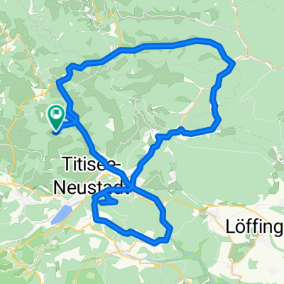
Die Abfahrt nach Frankreich
- 57.4 km
- 161 m
- 976 m
- Breitnau, Baden-Wurttemberg, Germany
A cycling route starting in Breitnau, Baden-Wurttemberg, Germany.
Overview
Jostal - Kappel - Hochfirst - Hammereisenbach - Thurner
Beautiful loop through the charming Jostal, passing by Neustadt and Kappel up to the Hochfirst
Those who still have the desire and stamina can round off the tour through the Uracher Valley up to the Thurner Plateau.
The tour leads mostly on quiet asphalt roads, only the short section from Saig over to the Hochfirst ramp is fine to coarse gravel. So it's almost entirely suitable for road bikes.
The attractive loop offers wonderful views over the High Black Forest and does not skimp on scenic charms, as well as plenty of elevation gain.
created this 5 years ago
Route quality
Quiet road
19.1 km
28 %
Road
5.5 km
8 %
Paved
54 km
(79 %)
Unpaved
2 km
(3 %)
Asphalt
47.8 km
70 %
Paved (undefined)
6.1 km
9 %
Continue with Bikemap
You would like to ride Neustädter Höhenschlag or customize it for your own trip? Here is what you can do with this Bikemap route:
Free trial for 3 days, or one-time payment. More about Bikemap Premium.
Discover more Premium features.
Get Bikemap PremiumFrom our community
Open it in the app