

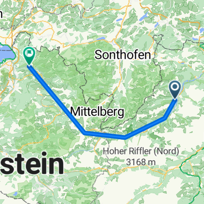
Vorderhornbach - Hahntennjoch
A cycling route starting in Vorderhornbach, Tyrol, Austria.
Overview
About this route
<p><em><strong>Absolute mountain experience on a well-developed, lightly trafficked mountain pass road in the Lechtal Alps</strong></em></p>
<p>Those who were not immediately discouraged by the first ramp (9%) and the following two (dark) road tunnels (note: they can easily be bypassed on the outside ;-) will be rewarded by flatter sections amid a dreamy and idyllic mountain backdrop.</p>
<p>However, the last few kilometers before the pass get quite tough again (constantly over 10%), so it is better not to attempt this route without proper preparation.</p>
<p>Don’t forget on the way: Push through! The descent will then make up for many things!! ;-)</p>
Translated, show original (German)- -:--
- Duration
- 20.1 km
- Distance
- 963 m
- Ascent
- 48 m
- Descent
- ---
- Avg. speed
- ---
- Max. altitude
Route quality
Waytypes & surfaces along the route
Waytypes
Track
2.8 km
(14 %)
Road
1.8 km
(9 %)
Surfaces
Paved
16.9 km
(84 %)
Unpaved
2.4 km
(12 %)
Asphalt
16.9 km
(84 %)
Unpaved (undefined)
2.2 km
(11 %)
Continue with Bikemap
Use, edit, or download this cycling route
You would like to ride Vorderhornbach - Hahntennjoch or customize it for your own trip? Here is what you can do with this Bikemap route:
Free features
- Save this route as favorite or in collections
- Copy & plan your own version of this route
- Sync your route with Garmin or Wahoo
Premium features
Free trial for 3 days, or one-time payment. More about Bikemap Premium.
- Navigate this route on iOS & Android
- Export a GPX / KML file of this route
- Create your custom printout (try it for free)
- Download this route for offline navigation
Discover more Premium features.
Get Bikemap PremiumFrom our community
Other popular routes starting in Vorderhornbach
 L264 58, Vorderhornbach nach Obermarkt 11, Gemeinde Reutte
- Distance
- 23.3 km
- Ascent
- 721 m
- Descent
- 829 m
- Location
- Vorderhornbach, Tyrol, Austria
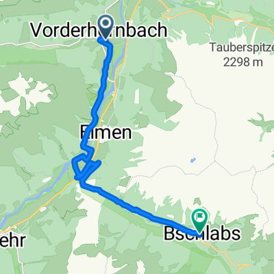 Vorderhornbach nach Bschlabs, Pfafflar
- Distance
- 13.2 km
- Ascent
- 401 m
- Descent
- 37 m
- Location
- Vorderhornbach, Tyrol, Austria
 Petersbergalm
- Distance
- 20 km
- Ascent
- 492 m
- Descent
- 490 m
- Location
- Vorderhornbach, Tyrol, Austria
 Von Vorderhornbach bis Buch
- Distance
- 71.9 km
- Ascent
- 297 m
- Descent
- 541 m
- Location
- Vorderhornbach, Tyrol, Austria
 Vorderhornbach - Hahntennjoch
- Distance
- 20.1 km
- Ascent
- 1,030 m
- Descent
- 113 m
- Location
- Vorderhornbach, Tyrol, Austria
 Kempten
- Distance
- 74.4 km
- Ascent
- 684 m
- Descent
- 960 m
- Location
- Vorderhornbach, Tyrol, Austria
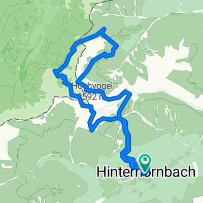 DC-down-Hochvogel
- Distance
- 20.8 km
- Ascent
- 2,283 m
- Descent
- 2,283 m
- Location
- Vorderhornbach, Tyrol, Austria
 Vorderhornbach - Petersbergalm (1250m)
- Distance
- 10.5 km
- Ascent
- 262 m
- Descent
- 84 m
- Location
- Vorderhornbach, Tyrol, Austria
Open it in the app