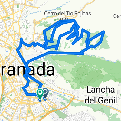
De Calle Virgen de la Esperanza a El Hidalgo
- 42.2 km
- 507 m
- 509 m
- Huétor Vega, Andalusia, Spain
A cycling route starting in Huétor Vega, Andalusia, Spain.
Overview
Route taken from Antonio Aguilera that we classify as moderate not due to the elevation changes or total length, as it is manageable in that sense (IBP: 53), but because a good part of the route runs through two narrow trails with a ravine right next to them: the one that takes us to the Llano de la Perdiz and the one that allows us to descend to the Silla del Moro (the latter also has an initial rockier section and stretches where the cork oaks encroach on the path making it impossible to avoid). They are not technical trails, but I do not consider them suitable for any novice since you absolutely have to control the bike, so that is said so no one who wants to do it is mistaken... Also, anyone who suffers from vertigo better abstain or not look. Otherwise, entertaining and with spectacular views. That said, the terrain is somewhat dry once past the Cortijo de Jesús del Valle and there are no fountains (one is marked that could be used in an extreme case, but it doesn’t inspire much confidence). Oh, and at the beginning you have to cross the Río Darro in two different places. The first with about 10-15cm at least at the time, and the second a little deeper but can be crossed by a log that lies across it.
created this 15 years ago
Continue with Bikemap
You would like to ride 10-8-10 Llano de la Perdiz (made in Antonio Aguilera) (IBP: 53) or customize it for your own trip? Here is what you can do with this Bikemap route:
Free trial for 3 days, or one-time payment. More about Bikemap Premium.
Discover more Premium features.
Get Bikemap PremiumFrom our community
Open it in the app