

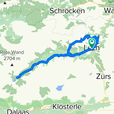
Rundtour Zug - Zuger Tobel - Gipslöcher - Oberlech - Tannberg - Zug
A cycling route starting in Lech, Vorarlberg, Austria.
Overview
About this route
Length: 11km
Starting elevation: 1500m above sea level.
Max. elevation difference: approx. 550m
Total ascent: approx. 570m
0.0km: Start from the parking lot on the road before Zug, asphalt/gravel to Zug.
1.5km: Asphalt to Zuger Alpe, approx. 70m vertical.
3.0km: Asphalt/gravel to the saddle, approx. 440m vertical.
6.0km: Asphalt/gravel, descent past the gypsum holes to Oberlech. Approx. -350m vertical.
8.5km: Gravel path over Rudalpe, above Tannberg (-100m).
10.0km: Hiking trail in the forest to the road.
11km: Arrival at the parking lot
- -:--
- Duration
- 11 km
- Distance
- 594 m
- Ascent
- 594 m
- Descent
- ---
- Avg. speed
- ---
- Max. altitude
Continue with Bikemap
Use, edit, or download this cycling route
You would like to ride Rundtour Zug - Zuger Tobel - Gipslöcher - Oberlech - Tannberg - Zug or customize it for your own trip? Here is what you can do with this Bikemap route:
Free features
- Save this route as favorite or in collections
- Copy & plan your own version of this route
- Sync your route with Garmin or Wahoo
Premium features
Free trial for 3 days, or one-time payment. More about Bikemap Premium.
- Navigate this route on iOS & Android
- Export a GPX / KML file of this route
- Create your custom printout (try it for free)
- Download this route for offline navigation
Discover more Premium features.
Get Bikemap PremiumFrom our community
Other popular routes starting in Lech
 Faschina
- Distance
- 110.6 km
- Ascent
- 2,364 m
- Descent
- 2,364 m
- Location
- Lech, Vorarlberg, Austria
 Route von Zug 528, Lech
- Distance
- 9.9 km
- Ascent
- 779 m
- Descent
- 103 m
- Location
- Lech, Vorarlberg, Austria
 Spullersee-Klosters-Zürs-Zug
- Distance
- 35.1 km
- Ascent
- 1,010 m
- Descent
- 995 m
- Location
- Lech, Vorarlberg, Austria
 Lech - Formarinsee - Oberlech
- Distance
- 34 km
- Ascent
- 956 m
- Descent
- 958 m
- Location
- Lech, Vorarlberg, Austria
 Rundtour Zug - Zuger Tobel - Gipslöcher - Oberlech - Tannberg - Zug
- Distance
- 11 km
- Ascent
- 594 m
- Descent
- 594 m
- Location
- Lech, Vorarlberg, Austria
 Tag 2: Lech - Formarinsee
- Distance
- 16.5 km
- Ascent
- 572 m
- Descent
- 184 m
- Location
- Lech, Vorarlberg, Austria
 2020_Alpencross01
- Distance
- 41.8 km
- Ascent
- 1,258 m
- Descent
- 1,274 m
- Location
- Lech, Vorarlberg, Austria
 Lech - Wart - Körbersee - Lech
- Distance
- 26.5 km
- Ascent
- 610 m
- Descent
- 610 m
- Location
- Lech, Vorarlberg, Austria
Open it in the app