

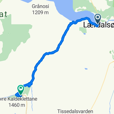
Lærdalflåm del t
A cycling route starting in Lærdal, Sogn og Fjordane, Norway.
Overview
About this route
- -:--
- Duration
- 16 km
- Distance
- 1,143 m
- Ascent
- 188 m
- Descent
- ---
- Avg. speed
- ---
- Max. altitude

Route quality
Waytypes & surfaces along the route
Waytypes
Cycleway
0.6 km
(4 %)
Access road
0.5 km
(3 %)
Surfaces
Paved
12.8 km
(80 %)
Unpaved
0.2 km
(1 %)
Asphalt
12.8 km
(80 %)
Gravel
0.2 km
(1 %)
Undefined
3 km
(19 %)
Continue with Bikemap
Use, edit, or download this cycling route
You would like to ride Lærdalflåm del t or customize it for your own trip? Here is what you can do with this Bikemap route:
Free features
- Save this route as favorite or in collections
- Copy & plan your own version of this route
- Sync your route with Garmin or Wahoo
Premium features
Free trial for 3 days, or one-time payment. More about Bikemap Premium.
- Navigate this route on iOS & Android
- Export a GPX / KML file of this route
- Create your custom printout (try it for free)
- Download this route for offline navigation
Discover more Premium features.
Get Bikemap PremiumFrom our community
Other popular routes starting in Lærdal
 Runde 32 - Jotunheimen rundt
- Distance
- 428.5 km
- Ascent
- 3,428 m
- Descent
- 3,422 m
- Location
- Lærdal, Sogn og Fjordane, Norway
 NO Laerdal-Aurlandsfjellet-Laerdal
- Distance
- 39.2 km
- Ascent
- 1,252 m
- Descent
- 1,252 m
- Location
- Lærdal, Sogn og Fjordane, Norway
 Lærdalflåm del t
- Distance
- 16 km
- Ascent
- 1,143 m
- Descent
- 188 m
- Location
- Lærdal, Sogn og Fjordane, Norway
 Lærdal - Brimi Fjellstuggu
- Distance
- 220.3 km
- Ascent
- 3,089 m
- Descent
- 2,237 m
- Location
- Lærdal, Sogn og Fjordane, Norway
 Jotunheimen rundt 2019
- Distance
- 423.7 km
- Ascent
- 3,547 m
- Descent
- 3,534 m
- Location
- Lærdal, Sogn og Fjordane, Norway
 Lærdal Radfahren
- Distance
- 64.1 km
- Ascent
- 1,711 m
- Descent
- 1,720 m
- Location
- Lærdal, Sogn og Fjordane, Norway
 Lærdal - Flåm
- Distance
- 52.8 km
- Ascent
- 1,875 m
- Descent
- 1,876 m
- Location
- Lærdal, Sogn og Fjordane, Norway
 Kongeveien, Borgund- Lærdalsøyri
- Distance
- 30.2 km
- Ascent
- 383 m
- Descent
- 792 m
- Location
- Lærdal, Sogn og Fjordane, Norway
Open it in the app