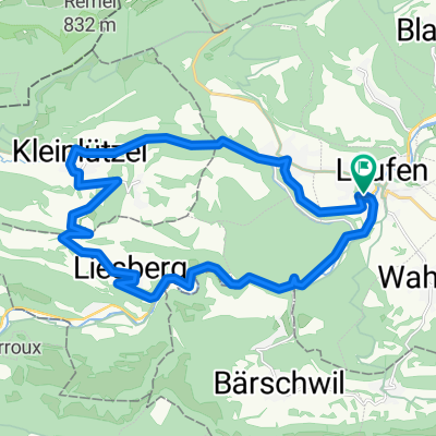
Laufen-Löwenburg
A cycling route starting in Laufen, Basel-Landschaft, Switzerland.
Overview
About this route
- -:--
- Duration
- 42.1 km
- Distance
- 641 m
- Ascent
- 640 m
- Descent
- ---
- Avg. speed
- ---
- Max. altitude
Route quality
Waytypes & surfaces along the route
Waytypes
Track
20.2 km
(48 %)
Quiet road
6.3 km
(15 %)
Surfaces
Paved
9.7 km
(23 %)
Unpaved
13.9 km
(33 %)
Gravel
8.8 km
(21 %)
Asphalt
5.1 km
(12 %)
Continue with Bikemap
Use, edit, or download this cycling route
You would like to ride Laufen-Löwenburg or customize it for your own trip? Here is what you can do with this Bikemap route:
Free features
- Save this route as favorite or in collections
- Copy & plan your own version of this route
- Sync your route with Garmin or Wahoo
Premium features
Free trial for 3 days, or one-time payment. More about Bikemap Premium.
- Navigate this route on iOS & Android
- Export a GPX / KML file of this route
- Create your custom printout (try it for free)
- Download this route for offline navigation
Discover more Premium features.
Get Bikemap PremiumFrom our community
Other popular routes starting in Laufen
- GemĂĽtliche Route in Laufen
- Distance
- 28.3 km
- Ascent
- 550 m
- Descent
- 553 m
- Location
- Laufen, Basel-Landschaft, Switzerland
- 19.01.2020 Huggerwald
- Distance
- 18.3 km
- Ascent
- 321 m
- Descent
- 320 m
- Location
- Laufen, Basel-Landschaft, Switzerland
- Huggerwald
- Distance
- 18.6 km
- Ascent
- 489 m
- Descent
- 491 m
- Location
- Laufen, Basel-Landschaft, Switzerland
- 14.01.2020 Sportliche Route in Laufen - March
- Distance
- 30.6 km
- Ascent
- 373 m
- Descent
- 373 m
- Location
- Laufen, Basel-Landschaft, Switzerland
- Easy1
- Distance
- 27.1 km
- Ascent
- 672 m
- Descent
- 677 m
- Location
- Laufen, Basel-Landschaft, Switzerland
- Laufen–Oberbeinwil–Nunningen–Seewen–Laufen
- Distance
- 47.2 km
- Ascent
- 682 m
- Descent
- 682 m
- Location
- Laufen, Basel-Landschaft, Switzerland
- Laufen-Löwenburg
- Distance
- 42.1 km
- Ascent
- 641 m
- Descent
- 640 m
- Location
- Laufen, Basel-Landschaft, Switzerland
- 31.08.2020 Bergmattenhof via Chall
- Distance
- 16.8 km
- Ascent
- 441 m
- Descent
- 441 m
- Location
- Laufen, Basel-Landschaft, Switzerland
Open it in the app