

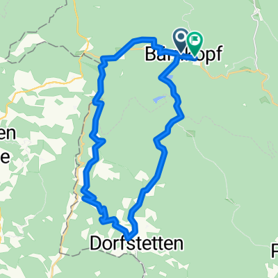
Duernbergstrecke - Luftkurort Bärnkopf
A cycling route starting in Bärnkopf, Lower Austria, Austria.
Overview
About this route
Start bei der Einkehrstube Wackelstein in Bärnkopf, gegenüber Friedhof links abbiegen, ca. 4 km auf ehemaliger Bahntrasse bis Annabild, ab hier steile Asphaltabfahrt ca. 3 km Autoverkehr, in Saggraben entlang dem Prinzbach, Forstschranken.<br />Ab hier stetiger Anstieg vorbei am Dürnbergteich bis Bärnkopf.
- -:--
- Duration
- 17.5 km
- Distance
- 361 m
- Ascent
- 373 m
- Descent
- ---
- Avg. speed
- ---
- Max. altitude
Route quality
Waytypes & surfaces along the route
Waytypes
Track
5.8 km
(33 %)
Quiet road
5.2 km
(30 %)
Surfaces
Paved
2.1 km
(12 %)
Unpaved
6.6 km
(37 %)
Gravel
5.3 km
(31 %)
Asphalt
2.1 km
(12 %)
Continue with Bikemap
Use, edit, or download this cycling route
You would like to ride Duernbergstrecke - Luftkurort Bärnkopf or customize it for your own trip? Here is what you can do with this Bikemap route:
Free features
- Save this route as favorite or in collections
- Copy & plan your own version of this route
- Sync your route with Garmin or Wahoo
Premium features
Free trial for 3 days, or one-time payment. More about Bikemap Premium.
- Navigate this route on iOS & Android
- Export a GPX / KML file of this route
- Create your custom printout (try it for free)
- Download this route for offline navigation
Discover more Premium features.
Get Bikemap PremiumFrom our community
Other popular routes starting in Bärnkopf
 Bärnkopf: Granittrail 3. Teiletappe
- Distance
- 45.4 km
- Ascent
- 638 m
- Descent
- 1,375 m
- Location
- Bärnkopf, Lower Austria, Austria
 4W7-1 Weinsberger Wald - Ysperklamm
- Distance
- 20.3 km
- Ascent
- 667 m
- Descent
- 668 m
- Location
- Bärnkopf, Lower Austria, Austria
 Duernbergstrecke - Luftkurort Bärnkopf
- Distance
- 17.5 km
- Ascent
- 361 m
- Descent
- 373 m
- Location
- Bärnkopf, Lower Austria, Austria
 Bärnkopf Dürnbergstrecke
- Distance
- 18.8 km
- Ascent
- 294 m
- Descent
- 294 m
- Location
- Bärnkopf, Lower Austria, Austria
 Route in Bärnkopf
- Distance
- 24.5 km
- Ascent
- 919 m
- Descent
- 893 m
- Location
- Bärnkopf, Lower Austria, Austria
 PZF Zwettl -> Bärnkopf - Zwettl
- Distance
- 43.3 km
- Ascent
- 675 m
- Descent
- 1,037 m
- Location
- Bärnkopf, Lower Austria, Austria
 Kombitour 6 & 19 Variante B
- Distance
- 51.5 km
- Ascent
- 1,131 m
- Descent
- 1,132 m
- Location
- Bärnkopf, Lower Austria, Austria
 Granittrail nr.3
- Distance
- 46.9 km
- Ascent
- 586 m
- Descent
- 1,324 m
- Location
- Bärnkopf, Lower Austria, Austria
Open it in the app