

@x∫?? nach @x∫??
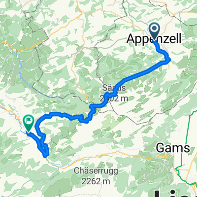
A cycling route starting in Appenzell, Appenzell Innerrhoden, Switzerland.
Overview
About this route
- 1 h 53 min
- Duration
- 29.6 km
- Distance
- 774 m
- Ascent
- 1,145 m
- Descent
- 15.7 km/h
- Avg. speed
- ---
- Max. altitude
Route photos


Route quality
Waytypes & surfaces along the route
Waytypes
Road
7.4 km
(25 %)
Track
7.1 km
(24 %)
Surfaces
Paved
13.6 km
(46 %)
Unpaved
9.8 km
(33 %)
Asphalt
12.1 km
(41 %)
Gravel
4.1 km
(14 %)
Continue with Bikemap
Use, edit, or download this cycling route
You would like to ride @x∫?? nach @x∫?? or customize it for your own trip? Here is what you can do with this Bikemap route:
Free features
- Save this route as favorite or in collections
- Copy & plan your own version of this route
- Sync your route with Garmin or Wahoo
Premium features
Free trial for 3 days, or one-time payment. More about Bikemap Premium.
- Navigate this route on iOS & Android
- Export a GPX / KML file of this route
- Create your custom printout (try it for free)
- Download this route for offline navigation
Discover more Premium features.
Get Bikemap PremiumFrom our community
Other popular routes starting in Appenzell
 Ebenalp 1G nach Tösstalstrasse
- Distance
- 89.5 km
- Ascent
- 630 m
- Descent
- 1,589 m
- Location
- Appenzell, Appenzell Innerrhoden, Switzerland
 Allauch 1989 15.5. Tag02
- Distance
- 172.8 km
- Ascent
- 3,735 m
- Descent
- 3,372 m
- Location
- Appenzell, Appenzell Innerrhoden, Switzerland
 Versuch I
- Distance
- 10.1 km
- Ascent
- 531 m
- Descent
- 536 m
- Location
- Appenzell, Appenzell Innerrhoden, Switzerland
 Säntis
- Distance
- 90.6 km
- Ascent
- 1,406 m
- Descent
- 1,416 m
- Location
- Appenzell, Appenzell Innerrhoden, Switzerland
 @x∫?? nach @x∫??
- Distance
- 29.6 km
- Ascent
- 774 m
- Descent
- 1,145 m
- Location
- Appenzell, Appenzell Innerrhoden, Switzerland
 A02aAppenzell-Stein-Nesslau
- Distance
- 40 km
- Ascent
- 1,209 m
- Descent
- 1,238 m
- Location
- Appenzell, Appenzell Innerrhoden, Switzerland
 bruelisau-staubern-hoher_kasten
- Distance
- 10.7 km
- Ascent
- 1,203 m
- Descent
- 351 m
- Location
- Appenzell, Appenzell Innerrhoden, Switzerland
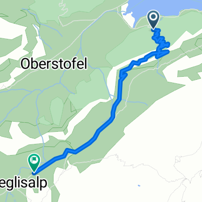 Wasserauen nach Meglisalp, Wasserauen
- Distance
- 2.9 km
- Ascent
- 540 m
- Descent
- 172 m
- Location
- Appenzell, Appenzell Innerrhoden, Switzerland
Open it in the app