

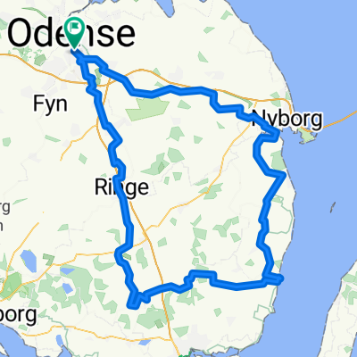
Tandem to Kerteminde and back
A cycling route starting in Odense, Region South Denmark, Denmark.
Overview
About this route
- 2 h 22 min
- Duration
- 47.1 km
- Distance
- 12 m
- Ascent
- 20 m
- Descent
- 19.9 km/h
- Avg. speed
- ---
- Max. altitude

Route quality
Waytypes & surfaces along the route
Waytypes
Road
17 km
(36 %)
Quiet road
12.2 km
(26 %)
Surfaces
Paved
44.3 km
(94 %)
Unpaved
0.5 km
(1 %)
Asphalt
44.3 km
(94 %)
Loose gravel
0.5 km
(1 %)
Undefined
2.4 km
(5 %)
Continue with Bikemap
Use, edit, or download this cycling route
You would like to ride Tandem to Kerteminde and back or customize it for your own trip? Here is what you can do with this Bikemap route:
Free features
- Save this route as favorite or in collections
- Copy & plan your own version of this route
- Sync your route with Garmin or Wahoo
Premium features
Free trial for 3 days, or one-time payment. More about Bikemap Premium.
- Navigate this route on iOS & Android
- Export a GPX / KML file of this route
- Create your custom printout (try it for free)
- Download this route for offline navigation
Discover more Premium features.
Get Bikemap PremiumFrom our community
Other popular routes starting in Odense
 Klippesalen 12, Odense SV to Klippesalen 12, Odense SV
- Distance
- 30.7 km
- Ascent
- 981 m
- Descent
- 984 m
- Location
- Odense, Region South Denmark, Denmark
 Odense to Bondebjerg
- Distance
- 11.8 km
- Ascent
- 61 m
- Descent
- 55 m
- Location
- Odense, Region South Denmark, Denmark
 18 July 2020 - tandem
- Distance
- 36.1 km
- Ascent
- 74 m
- Descent
- 74 m
- Location
- Odense, Region South Denmark, Denmark
 Tandem to Kerteminde and back
- Distance
- 47.1 km
- Ascent
- 12 m
- Descent
- 20 m
- Location
- Odense, Region South Denmark, Denmark
 Lindeallé, Odense M to Lindeallé, Odense M
- Distance
- 122.9 km
- Ascent
- 495 m
- Descent
- 496 m
- Location
- Odense, Region South Denmark, Denmark
 Odense to Slagelse
- Distance
- 79.6 km
- Ascent
- 196 m
- Descent
- 165 m
- Location
- Odense, Region South Denmark, Denmark
 Carl Nielsens Kvarter, Odense C to Carl Nielsens Kvarter, Odense C
- Distance
- 26.6 km
- Ascent
- 72 m
- Descent
- 70 m
- Location
- Odense, Region South Denmark, Denmark
 Brændekilde-Hesbjerg Skov
- Distance
- 31.3 km
- Ascent
- 124 m
- Descent
- 122 m
- Location
- Odense, Region South Denmark, Denmark
Open it in the app