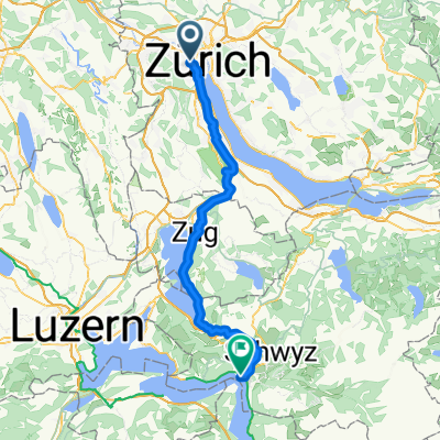
2-Seen Runde
A cycling route starting in Zürich (Kreis 4) / Hard, Canton of Zurich, Switzerland.
Overview
About this route
- 3 h 50 min
- Duration
- 84.4 km
- Distance
- 771 m
- Ascent
- 768 m
- Descent
- 22.1 km/h
- Avg. speed
- ---
- Max. altitude
Route quality
Waytypes & surfaces along the route
Waytypes
Path
16 km
(19 %)
Pedestrian area
11.8 km
(14 %)
Surfaces
Paved
73.4 km
(87 %)
Unpaved
0.8 km
(1 %)
Asphalt
73.4 km
(87 %)
Loose gravel
0.8 km
(1 %)
Undefined
10.1 km
(12 %)
Continue with Bikemap
Use, edit, or download this cycling route
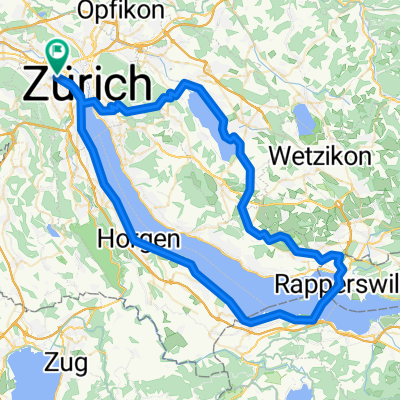
You would like to ride 2-Seen Runde or customize it for your own trip? Here is what you can do with this Bikemap route:
Free features
- Save this route as favorite or in collections
- Copy & plan your own version of this route
- Split it into stages to create a multi-day tour
- Sync your route with Garmin or Wahoo
Premium features
Free trial for 3 days, or one-time payment. More about Bikemap Premium.
- Navigate this route on iOS & Android
- Export a GPX / KML file of this route
- Create your custom printout (try it for free)
- Download this route for offline navigation
Discover more Premium features.
Get Bikemap PremiumFrom our community
Other popular routes starting in Zürich (Kreis 4) / Hard
- Grosse Albisrunde
- Distance
- 73.2 km
- Ascent
- 727 m
- Descent
- 727 m
- Location
- Zürich (Kreis 4) / Hard, Canton of Zurich, Switzerland
- Einfache Fahrt in Zürich
- Distance
- 14.5 km
- Ascent
- 64 m
- Descent
- 63 m
- Location
- Zürich (Kreis 4) / Hard, Canton of Zurich, Switzerland
- Zürich-Rickenbach
- Distance
- 54.7 km
- Ascent
- 625 m
- Descent
- 348 m
- Location
- Zürich (Kreis 4) / Hard, Canton of Zurich, Switzerland
- Badener Stallikon Bremgarten Birmensdorf
- Distance
- 60.3 km
- Ascent
- 809 m
- Descent
- 809 m
- Location
- Zürich (Kreis 4) / Hard, Canton of Zurich, Switzerland
- Buchenegg_Hausstrecke
- Distance
- 31.1 km
- Ascent
- 508 m
- Descent
- 489 m
- Location
- Zürich (Kreis 4) / Hard, Canton of Zurich, Switzerland
- Zürich Flaach Diretissima
- Distance
- 36.2 km
- Ascent
- 637 m
- Descent
- 565 m
- Location
- Zürich (Kreis 4) / Hard, Canton of Zurich, Switzerland
- Saisonstart
- Distance
- 13.8 km
- Ascent
- 275 m
- Descent
- 225 m
- Location
- Zürich (Kreis 4) / Hard, Canton of Zurich, Switzerland
- Zürich nach Ingenbohl
- Distance
- 61.2 km
- Ascent
- 710 m
- Descent
- 693 m
- Location
- Zürich (Kreis 4) / Hard, Canton of Zurich, Switzerland
Open it in the app