

Rund um die Hohe Wand 1
A cycling route starting in Waldegg, Lower Austria, Austria.
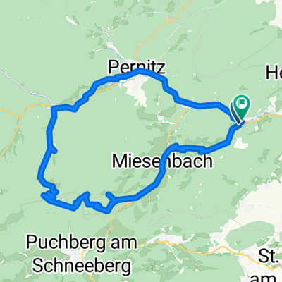
Overview
About this route
The strenuous highlight of this Hohe Wand circuit variant is the Dürnbacher Höhe from Waldegg to Miesenbach. A steep narrow road that really takes a toll on the legs.
- -:--
- Duration
- 45.8 km
- Distance
- 662 m
- Ascent
- 662 m
- Descent
- ---
- Avg. speed
- ---
- Max. altitude
Route quality
Waytypes & surfaces along the route
Waytypes
Road
7.8 km
(17 %)
Quiet road
3.2 km
(7 %)
Surfaces
Paved
34.8 km
(76 %)
Unpaved
2.3 km
(5 %)
Asphalt
34.8 km
(76 %)
Gravel
1.4 km
(3 %)
Continue with Bikemap
Use, edit, or download this cycling route
You would like to ride Rund um die Hohe Wand 1 or customize it for your own trip? Here is what you can do with this Bikemap route:
Free features
- Save this route as favorite or in collections
- Copy & plan your own version of this route
- Sync your route with Garmin or Wahoo
Premium features
Free trial for 3 days, or one-time payment. More about Bikemap Premium.
- Navigate this route on iOS & Android
- Export a GPX / KML file of this route
- Create your custom printout (try it for free)
- Download this route for offline navigation
Discover more Premium features.
Get Bikemap PremiumFrom our community
Other popular routes starting in Waldegg
 GT Öhler Schutzhaus Original
- Distance
- 46.5 km
- Ascent
- 1,659 m
- Descent
- 1,662 m
- Location
- Waldegg, Lower Austria, Austria
 Hernstein
- Distance
- 42.4 km
- Ascent
- 393 m
- Descent
- 393 m
- Location
- Waldegg, Lower Austria, Austria
 Oed 5 nach Rathausplatz 1, Leobersdorf
- Distance
- 24.4 km
- Ascent
- 28 m
- Descent
- 211 m
- Location
- Waldegg, Lower Austria, Austria
 Rund um die Hohe Wand 1
- Distance
- 45.8 km
- Ascent
- 662 m
- Descent
- 662 m
- Location
- Waldegg, Lower Austria, Austria
 Radrunde von Waldegg nach Wiener Neustadt
- Distance
- 24.6 km
- Ascent
- 75 m
- Descent
- 193 m
- Location
- Waldegg, Lower Austria, Austria
 Waldegg - Miesenbach - Scheimhütten - Tour
- Distance
- 35.3 km
- Ascent
- 1,210 m
- Descent
- 1,210 m
- Location
- Waldegg, Lower Austria, Austria
 Postlstraße, Hohe Wand nach Waisenhausgasse, Wiener Neustadt
- Distance
- 25 km
- Ascent
- 59 m
- Descent
- 668 m
- Location
- Waldegg, Lower Austria, Austria
 Warm up Frühling 2010
- Distance
- 45.1 km
- Ascent
- 760 m
- Descent
- 786 m
- Location
- Waldegg, Lower Austria, Austria
Open it in the app