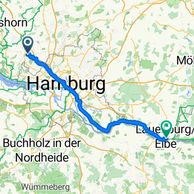
Grüner Ring HH Süd
A cycling route starting in Pinneberg, Schleswig-Holstein, Germany.
Overview
About this route
- -:--
- Duration
- 57 km
- Distance
- 187 m
- Ascent
- 195 m
- Descent
- ---
- Avg. speed
- ---
- Max. altitude
Continue with Bikemap
Use, edit, or download this cycling route
You would like to ride Grüner Ring HH Süd or customize it for your own trip? Here is what you can do with this Bikemap route:
Free features
- Save this route as favorite or in collections
- Copy & plan your own version of this route
- Sync your route with Garmin or Wahoo
Premium features
Free trial for 3 days, or one-time payment. More about Bikemap Premium.
- Navigate this route on iOS & Android
- Export a GPX / KML file of this route
- Create your custom printout (try it for free)
- Download this route for offline navigation
Discover more Premium features.
Get Bikemap PremiumFrom our community
Other popular routes starting in Pinneberg
Grüner Ring HH Süd- Distance
- 57 km
- Ascent
- 187 m
- Descent
- 195 m
- Location
- Pinneberg, Schleswig-Holstein, Germany
Pinnberg Norden Pinnberg 35km- Distance
- 37.1 km
- Ascent
- 61 m
- Descent
- 61 m
- Location
- Pinneberg, Schleswig-Holstein, Germany
Aboretum, Ellerhoop- Distance
- 9.5 km
- Ascent
- 41 m
- Descent
- 29 m
- Location
- Pinneberg, Schleswig-Holstein, Germany
Glückstädter Matjeswochen 09`- Distance
- 54.1 km
- Ascent
- 17 m
- Descent
- 27 m
- Location
- Pinneberg, Schleswig-Holstein, Germany
Arbeit Pinneberg - Hamburg- Distance
- 16.6 km
- Ascent
- 57 m
- Descent
- 44 m
- Location
- Pinneberg, Schleswig-Holstein, Germany
Route zu Apartment Plöner See- Distance
- 97.3 km
- Ascent
- 302 m
- Descent
- 272 m
- Location
- Pinneberg, Schleswig-Holstein, Germany
zum Klövenstehn- Distance
- 12.2 km
- Ascent
- 0 m
- Descent
- 5 m
- Location
- Pinneberg, Schleswig-Holstein, Germany
Tour 2012- Distance
- 2,191.1 km
- Ascent
- 3,867 m
- Descent
- 3,876 m
- Location
- Pinneberg, Schleswig-Holstein, Germany
Open it in the app


