

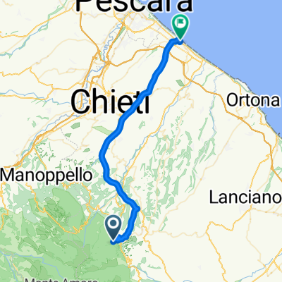
Giro della Maiella con salita al Blockhaus
A cycling route starting in Pennapiedimonte, Abruzzo, Italy.
Overview
About this route
- -:--
- Duration
- 152.4 km
- Distance
- 3,132 m
- Ascent
- 3,178 m
- Descent
- ---
- Avg. speed
- ---
- Max. altitude

Route quality
Waytypes & surfaces along the route
Waytypes
Road
25.9 km
(17 %)
Quiet road
19.8 km
(13 %)
Surfaces
Paved
138.7 km
(91 %)
Unpaved
3 km
(2 %)
Asphalt
137.2 km
(90 %)
Concrete
1.5 km
(1 %)
Continue with Bikemap
Use, edit, or download this cycling route
You would like to ride Giro della Maiella con salita al Blockhaus or customize it for your own trip? Here is what you can do with this Bikemap route:
Free features
- Save this route as favorite or in collections
- Copy & plan your own version of this route
- Split it into stages to create a multi-day tour
- Sync your route with Garmin or Wahoo
Premium features
Free trial for 3 days, or one-time payment. More about Bikemap Premium.
- Navigate this route on iOS & Android
- Export a GPX / KML file of this route
- Create your custom printout (try it for free)
- Download this route for offline navigation
Discover more Premium features.
Get Bikemap PremiumFrom our community
Other popular routes starting in Pennapiedimonte
 maltellese gobbe di selva romana
- Distance
- 36.7 km
- Ascent
- 2,405 m
- Descent
- 2,419 m
- Location
- Pennapiedimonte, Abruzzo, Italy
 004 - Bocca di valle - Sant Eufemia - Pretoro
- Distance
- 18.2 km
- Ascent
- 423 m
- Descent
- 443 m
- Location
- Pennapiedimonte, Abruzzo, Italy
 Italie : Pescara - Blockhaus
- Distance
- 189.2 km
- Ascent
- 3,275 m
- Descent
- 5,341 m
- Location
- Pennapiedimonte, Abruzzo, Italy
 Da Guardiagrele a Via Bocca di Valle 140
- Distance
- 5 km
- Ascent
- 216 m
- Descent
- 641 m
- Location
- Pennapiedimonte, Abruzzo, Italy
 T - Blockhaus da passo Lanciano
- Distance
- 11.9 km
- Ascent
- 362 m
- Descent
- 362 m
- Location
- Pennapiedimonte, Abruzzo, Italy
 Bocca di Valle-Pomilio-Pennapiedimonte
- Distance
- 20.9 km
- Ascent
- 1,392 m
- Descent
- 1,392 m
- Location
- Pennapiedimonte, Abruzzo, Italy
 Itinerario Indro Montanelli, Rapino nach Sentiero F2: Anello della Cascata di San Giovanni, Guardiagrele
- Distance
- 5.7 km
- Ascent
- 8 m
- Descent
- 1,135 m
- Location
- Pennapiedimonte, Abruzzo, Italy
 Da Strada Senza Nome a Via Monfalcone
- Distance
- 37.5 km
- Ascent
- 26 m
- Descent
- 991 m
- Location
- Pennapiedimonte, Abruzzo, Italy
Open it in the app