

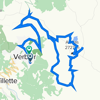
V2V - D1
A cycling route starting in Verbier, Valais, Switzerland.
Overview
About this route
Verbier to Interlarken - Including Croix de coeur, Sanetsch (descent in lift to Gsteig) and Saanenmöser
- -:--
- Duration
- 152.1 km
- Distance
- 2,637 m
- Ascent
- 3,557 m
- Descent
- ---
- Avg. speed
- ---
- Max. altitude

Continue with Bikemap
Use, edit, or download this cycling route
You would like to ride V2V - D1 or customize it for your own trip? Here is what you can do with this Bikemap route:
Free features
- Save this route as favorite or in collections
- Copy & plan your own version of this route
- Split it into stages to create a multi-day tour
- Sync your route with Garmin or Wahoo
Premium features
Free trial for 3 days, or one-time payment. More about Bikemap Premium.
- Navigate this route on iOS & Android
- Export a GPX / KML file of this route
- Create your custom printout (try it for free)
- Download this route for offline navigation
Discover more Premium features.
Get Bikemap PremiumFrom our community
Other popular routes starting in Verbier
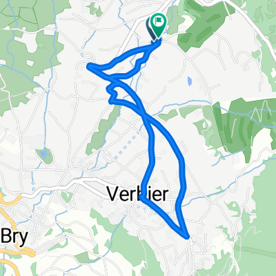
 Tag 2 Verbier-Mauvoisin
- Distance
- 71.5 km
- Ascent
- 2,644 m
- Descent
- 2,416 m
- Location
- Verbier, Valais, Switzerland
 Verbier to the Chanrion Hut
- Distance
- 73.4 km
- Ascent
- 2,319 m
- Descent
- 2,319 m
- Location
- Verbier, Valais, Switzerland
 Above Verbier
- Distance
- 34.5 km
- Ascent
- 1,191 m
- Descent
- 1,172 m
- Location
- Verbier, Valais, Switzerland
 testrunde 2 Verbier
- Distance
- 3.8 km
- Ascent
- 123 m
- Descent
- 120 m
- Location
- Verbier, Valais, Switzerland
 Grand Raid Verbier - Grimentz 2009
- Distance
- 114.4 km
- Ascent
- 3,947 m
- Descent
- 3,853 m
- Location
- Verbier, Valais, Switzerland
 Aigle - Croix de Coeur
- Distance
- 189.4 km
- Ascent
- 3,932 m
- Descent
- 5,451 m
- Location
- Verbier, Valais, Switzerland
 Grand Raid Verbier-Grimentz
- Distance
- 127.8 km
- Ascent
- 4,109 m
- Descent
- 3,996 m
- Location
- Verbier, Valais, Switzerland
 De Rue de Ransou 72, Bagnes à Rue de Ransou 72, Bagnes
- Distance
- 132 km
- Ascent
- 2,810 m
- Descent
- 2,812 m
- Location
- Verbier, Valais, Switzerland
Open it in the app