

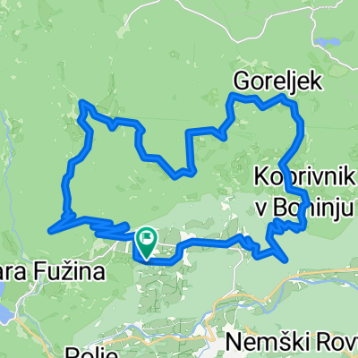
Bohinjska Bistrica - Idrija - Branik
A cycling route starting in Bohinjska Bistrica, Bohinj Municipality, Slovenia.
Overview
About this route
By train to Bohinjska Bistrica, then up a steep road to Sorica, followed by a descent to Podbrdo. We continue on to Bača pri Modreju, where we turn towards Idrija on a somewhat boring road. From Idrija there's a climb to Godovič. This part of the road is quite busy. Through Godovič the road is flat, but soon a gentle ascent begins towards Črni Vrh. There we again encounter some flat sections. This is a good place to rest before the final climb and the long descent to Col and onwards to Ajdovščina. Then the last stretch to Branik.
- -:--
- Duration
- 133.5 km
- Distance
- 1,618 m
- Ascent
- 2,054 m
- Descent
- ---
- Avg. speed
- ---
- Max. altitude

Route quality
Waytypes & surfaces along the route
Waytypes
Quiet road
8 km
(6 %)
Access road
1.3 km
(1 %)
Surfaces
Paved
98.8 km
(74 %)
Asphalt
98.8 km
(74 %)
Undefined
34.7 km
(26 %)
Continue with Bikemap
Use, edit, or download this cycling route
You would like to ride Bohinjska Bistrica - Idrija - Branik or customize it for your own trip? Here is what you can do with this Bikemap route:
Free features
- Save this route as favorite or in collections
- Copy & plan your own version of this route
- Split it into stages to create a multi-day tour
- Sync your route with Garmin or Wahoo
Premium features
Free trial for 3 days, or one-time payment. More about Bikemap Premium.
- Navigate this route on iOS & Android
- Export a GPX / KML file of this route
- Create your custom printout (try it for free)
- Download this route for offline navigation
Discover more Premium features.
Get Bikemap PremiumFrom our community
Other popular routes starting in Bohinjska Bistrica
 Snail-like route in Bohinjska Bistrica
- Distance
- 20.1 km
- Ascent
- 146 m
- Descent
- 155 m
- Location
- Bohinjska Bistrica, Bohinj Municipality, Slovenia
 b.b- koprivnik-gorjuse-b.b
- Distance
- 46.6 km
- Ascent
- 888 m
- Descent
- 889 m
- Location
- Bohinjska Bistrica, Bohinj Municipality, Slovenia
 Slow ride in Bohinj
- Distance
- 7.4 km
- Ascent
- 187 m
- Descent
- 248 m
- Location
- Bohinjska Bistrica, Bohinj Municipality, Slovenia
 Po pobočjih južnih bohinjskih gora
- Distance
- 30.4 km
- Ascent
- 671 m
- Descent
- 671 m
- Location
- Bohinjska Bistrica, Bohinj Municipality, Slovenia
 Kolesarski izlet na Uskovnico in mimo Zajamnikov do Goreljka
- Distance
- 31.7 km
- Ascent
- 1,090 m
- Descent
- 1,092 m
- Location
- Bohinjska Bistrica, Bohinj Municipality, Slovenia
 Pokljuka MTB
- Distance
- 22.9 km
- Ascent
- 832 m
- Descent
- 835 m
- Location
- Bohinjska Bistrica, Bohinj Municipality, Slovenia
 BOHINJ-SAVICA-OKOLI JEZERA
- Distance
- 35 km
- Ascent
- 472 m
- Descent
- 483 m
- Location
- Bohinjska Bistrica, Bohinj Municipality, Slovenia
 Letoviška ulica, Bohinjska Bistrica do Ribčev Laz, Bohinjsko Jezero
- Distance
- 8.3 km
- Ascent
- 73 m
- Descent
- 67 m
- Location
- Bohinjska Bistrica, Bohinj Municipality, Slovenia
Open it in the app