Załęże 52, Stany do Kajmowska, Tarnobrzeg
- 42 km
- 120 m
- 144 m
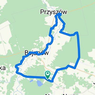
- Bojanów, Subcarpathian Voivodeship, Poland
A cycling route starting in Bojanów, Subcarpathian Voivodeship, Poland.
Overview
Przybyszów – Stany – Bojanów – Kopcie – Płazówka – Mechowiec – KOLBUSZOWA (ul.Obrońców Pokoju) – Nowa Wieś – Trześń – Niwiska – Dobrynin – Tuszyma – Przecław – Ruda – RADOMYŚL WIELKI (ul.Wałowa) – Radgoszcz – Żdżary – Nieczajna Górna – DĄBROWA TARNOWSKA (975) – Morzychna – Studzienki – Żabno (973) – Nieciecza (stadion) – Żabno (973) – Łęg Tarnowski – TARNÓW (pociąg)
created this 5 years ago
Route quality
Road
87.7 km
(67 %)
Quiet road
14.4 km
(11 %)
Paved
113.9 km
(87 %)
Asphalt
111.3 km
(85 %)
Paved (undefined)
2.6 km
(2 %)
Undefined
17 km
(13 %)
Continue with Bikemap
You would like to ride Tarnów 2020 dzień 2 or customize it for your own trip? Here is what you can do with this Bikemap route:
Free trial for 3 days, or one-time payment. More about Bikemap Premium.
Discover more Premium features.
Get Bikemap PremiumFrom our community
Open it in the app