

čez Boč
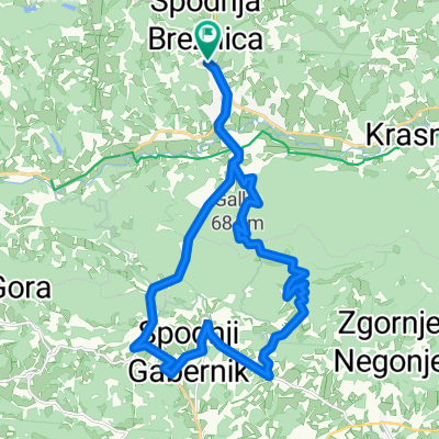
A cycling route starting in Poljčane, Občina Poljčane, Slovenia.
Overview
About this route
I warmed up my legs, so I warmed up at Pečica, then ascent and descent to Kostrivnica, and back home through Pečica.
- -:--
- Duration
- 31.3 km
- Distance
- 688 m
- Ascent
- 691 m
- Descent
- ---
- Avg. speed
- ---
- Max. altitude

Route quality
Waytypes & surfaces along the route
Waytypes
Quiet road
9.4 km
(30 %)
Road
2.2 km
(7 %)
Surfaces
Paved
19.4 km
(62 %)
Asphalt
19.4 km
(62 %)
Undefined
11.9 km
(38 %)
Continue with Bikemap
Use, edit, or download this cycling route
You would like to ride čez Boč or customize it for your own trip? Here is what you can do with this Bikemap route:
Free features
- Save this route as favorite or in collections
- Copy & plan your own version of this route
- Sync your route with Garmin or Wahoo
Premium features
Free trial for 3 days, or one-time payment. More about Bikemap Premium.
- Navigate this route on iOS & Android
- Export a GPX / KML file of this route
- Create your custom printout (try it for free)
- Download this route for offline navigation
Discover more Premium features.
Get Bikemap PremiumFrom our community
Other popular routes starting in Poljčane
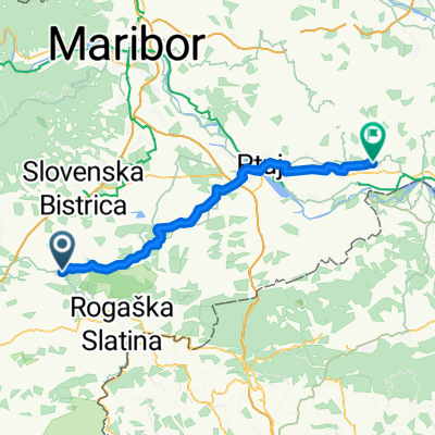
 čez Boč iz Kostrivnice
- Distance
- 23.2 km
- Ascent
- 585 m
- Descent
- 589 m
- Location
- Poljčane, Občina Poljčane, Slovenia
 MTB: Poljčane - Boč (Stolp)
- Distance
- 26.2 km
- Ascent
- 934 m
- Descent
- 938 m
- Location
- Poljčane, Občina Poljčane, Slovenia
 Loče - Ribniki Jernej - Lubicno - Loče
- Distance
- 17 km
- Ascent
- 368 m
- Descent
- 369 m
- Location
- Poljčane, Občina Poljčane, Slovenia
 Zbelovo - Celjska Koča
- Distance
- 36 km
- Ascent
- 730 m
- Descent
- 376 m
- Location
- Poljčane, Občina Poljčane, Slovenia
 Poljčane - Zavrč
- Distance
- 54.4 km
- Ascent
- 411 m
- Descent
- 470 m
- Location
- Poljčane, Občina Poljčane, Slovenia
 STKP - Velikonočnica - Boč - Ljubična gora
- Distance
- 21.2 km
- Ascent
- 339 m
- Descent
- 339 m
- Location
- Poljčane, Občina Poljčane, Slovenia
 krog do Maribora
- Distance
- 71.2 km
- Ascent
- 235 m
- Descent
- 232 m
- Location
- Poljčane, Občina Poljčane, Slovenia
 Tur po Sloveniji I
- Distance
- 355.2 km
- Ascent
- 3,896 m
- Descent
- 3,885 m
- Location
- Poljčane, Občina Poljčane, Slovenia
Open it in the app