

Day 03
A cycling route starting in Chang-hua, Taiwan, Taiwan.
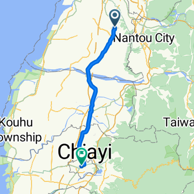
Overview
About this route
台中烏日→嘉義市
彰化阿三肉圓,彰化扇形車庫、鹿港,西螺大橋
- -:--
- Duration
- 97.7 km
- Distance
- 70 m
- Ascent
- 63 m
- Descent
- ---
- Avg. speed
- ---
- Max. altitude

Route quality
Waytypes & surfaces along the route
Waytypes
Road
16.6 km
(17 %)
Access road
13.7 km
(14 %)
Surfaces
Paved
41 km
(42 %)
Asphalt
39.1 km
(40 %)
Paved (undefined)
2 km
(2 %)
Undefined
56.6 km
(58 %)
Continue with Bikemap
Use, edit, or download this cycling route
You would like to ride Day 03 or customize it for your own trip? Here is what you can do with this Bikemap route:
Free features
- Save this route as favorite or in collections
- Copy & plan your own version of this route
- Split it into stages to create a multi-day tour
- Sync your route with Garmin or Wahoo
Premium features
Free trial for 3 days, or one-time payment. More about Bikemap Premium.
- Navigate this route on iOS & Android
- Export a GPX / KML file of this route
- Create your custom printout (try it for free)
- Download this route for offline navigation
Discover more Premium features.
Get Bikemap PremiumFrom our community
Other popular routes starting in Chang-hua
 聖安路
聖安路- Distance
- 18.6 km
- Ascent
- 204 m
- Descent
- 126 m
- Location
- Chang-hua, Taiwan, Taiwan
 穩定的乘坐 烏日區
- Distance
- 38 km
- Ascent
- 38 m
- Descent
- 69 m
- Location
- Chang-hua, Taiwan, Taiwan
 Duke of Edinburgh's (International) Award - Gold Adventurous Journey for Experienced Bikers
- Distance
- 416.4 km
- Ascent
- 226 m
- Descent
- 228 m
- Location
- Chang-hua, Taiwan, Taiwan
 寧靜的路線 鹿港鎮
- Distance
- 16.8 km
- Ascent
- 16 m
- Descent
- 13 m
- Location
- Chang-hua, Taiwan, Taiwan
 C2C -7童軍鐵騎 長征七號 路線規劃圖
- Distance
- 135.4 km
- Ascent
- 692 m
- Descent
- 693 m
- Location
- Chang-hua, Taiwan, Taiwan
 Chang-hua - Pizitou
- Distance
- 63.6 km
- Ascent
- 134 m
- Descent
- 124 m
- Location
- Chang-hua, Taiwan, Taiwan
 139 縣道簡略指引
- Distance
- 54.4 km
- Ascent
- 731 m
- Descent
- 523 m
- Location
- Chang-hua, Taiwan, Taiwan
 ride through Dacun Town
- Distance
- 11 km
- Ascent
- 26 m
- Descent
- 25 m
- Location
- Chang-hua, Taiwan, Taiwan
Open it in the app