Tour de Natur (Nordeifel)
A cycling route starting in Blankenheim, North Rhine-Westphalia, Germany.
Overview
About this route
Tour de Natur (Nordeifel)
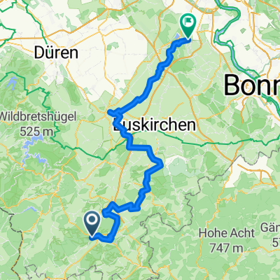
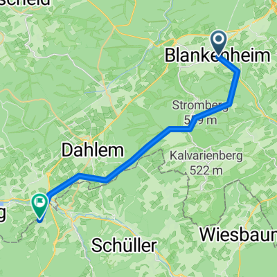
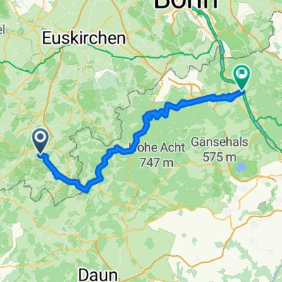
The journey for the bike tour is by train from Cologne to Blankenheim-Wald. On the way from Blankenheim-Wald to Weilerswist, there are indeed 54 kilometers to cover. However, most of the route is downhill. In Nettersheim, there is the only longer ascent ahead. But don't worry, the path through the Genfbachtal up to Engelgau is not too steep. After that, we pass through Holzmülhem and the ERFT source. Region: Nordeifel Starting point: Nettersheim Railway Station Places along the route: Station, Blankenheim-Wald - Netterheim - Engelgau - Frohngau - Holzmülheim - Bad Munstereifel - Iversheim - Arloff - Kreuzweingarten - Euskirchen - Großbüllesheim - Derkum - Weilerswist Station.- -:--
- Duration
- 53.4 km
- Distance
- 105 m
- Ascent
- 484 m
- Descent
- ---
- Avg. speed
- ---
- Max. altitude
Route quality
Waytypes & surfaces along the route
Waytypes
Track
18.7 km
(35 %)
Quiet road
16.6 km
(31 %)
Surfaces
Paved
34.7 km
(65 %)
Unpaved
5.3 km
(10 %)
Asphalt
30.5 km
(57 %)
Paved (undefined)
4.3 km
(8 %)
Route highlights
Points of interest along the route
Point of interest after 10.5 km
Genfbachtal
Photo after 16.8 km
die Erftquelle in Holzmülheim
Photo after 27.1 km
Bad Münstereifel Brücke
Continue with Bikemap
Use, edit, or download this cycling route
You would like to ride Tour de Natur (Nordeifel) or customize it for your own trip? Here is what you can do with this Bikemap route:
Free features
- Save this route as favorite or in collections
- Copy & plan your own version of this route
- Sync your route with Garmin or Wahoo
Premium features
Free trial for 3 days, or one-time payment. More about Bikemap Premium.
- Navigate this route on iOS & Android
- Export a GPX / KML file of this route
- Create your custom printout (try it for free)
- Download this route for offline navigation
Discover more Premium features.
Get Bikemap PremiumFrom our community
Other popular routes starting in Blankenheim
- Erfttour 2016
- Distance
- 126.9 km
- Ascent
- 80 m
- Descent
- 538 m
- Location
- Blankenheim, North Rhine-Westphalia, Germany
- Route der Vielseitigkeit
- Distance
- 59.3 km
- Ascent
- 134 m
- Descent
- 507 m
- Location
- Blankenheim, North Rhine-Westphalia, Germany
- Ahrtalradweg
- Distance
- 95.5 km
- Ascent
- 142 m
- Descent
- 581 m
- Location
- Blankenheim, North Rhine-Westphalia, Germany
- Blankenheim - Rundkurs
- Distance
- 32.8 km
- Ascent
- 576 m
- Descent
- 576 m
- Location
- Blankenheim, North Rhine-Westphalia, Germany
- Eifel
- Distance
- 45.3 km
- Ascent
- 496 m
- Descent
- 461 m
- Location
- Blankenheim, North Rhine-Westphalia, Germany
- Vulkaneifelrunde
- Distance
- 84.3 km
- Ascent
- 820 m
- Descent
- 820 m
- Location
- Blankenheim, North Rhine-Westphalia, Germany
- Blankenheim Wald - Nettersheim - Swisttal
- Distance
- 54.8 km
- Ascent
- 159 m
- Descent
- 515 m
- Location
- Blankenheim, North Rhine-Westphalia, Germany
- Ahrtour
- Distance
- 83.8 km
- Ascent
- 113 m
- Descent
- 557 m
- Location
- Blankenheim, North Rhine-Westphalia, Germany
Open it in the app