

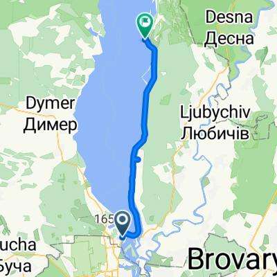
НВБЧ- СВТШ - ИРП - ПВ (западное направление)
A cycling route starting in Vyshhorod, Kyiv Oblast, Ukraine.
Overview
About this route
- -:--
- Duration
- 58.7 km
- Distance
- 223 m
- Ascent
- 212 m
- Descent
- ---
- Avg. speed
- ---
- Max. altitude

Route highlights
Points of interest along the route
Point of interest after 20.1 km
Избушка
Point of interest after 20.4 km
Памятник
Point of interest after 23.7 km
Церковь
Point of interest after 23.7 km
Памятник
Point of interest after 27.9 km
Дамба
Point of interest after 43.1 km
Церковь
Continue with Bikemap
Use, edit, or download this cycling route
You would like to ride НВБЧ- СВТШ - ИРП - ПВ (западное направление) or customize it for your own trip? Here is what you can do with this Bikemap route:
Free features
- Save this route as favorite or in collections
- Copy & plan your own version of this route
- Sync your route with Garmin or Wahoo
Premium features
Free trial for 3 days, or one-time payment. More about Bikemap Premium.
- Navigate this route on iOS & Android
- Export a GPX / KML file of this route
- Create your custom printout (try it for free)
- Download this route for offline navigation
Discover more Premium features.
Get Bikemap PremiumFrom our community
Other popular routes starting in Vyshhorod
 Маршрут #1, возле Мисливець, Киев
- Distance
- 10 km
- Ascent
- 61 m
- Descent
- 56 m
- Location
- Vyshhorod, Kyiv Oblast, Ukraine
 киевское море
- Distance
- 13.6 km
- Ascent
- 105 m
- Descent
- 107 m
- Location
- Vyshhorod, Kyiv Oblast, Ukraine
 От вулиця Прирічна 27В, Київ до вулиця Ярославська 14, Київ
- Distance
- 9.4 km
- Ascent
- 75 m
- Descent
- 75 m
- Location
- Vyshhorod, Kyiv Oblast, Ukraine
 Десна
Десна- Distance
- 110.8 km
- Ascent
- 71 m
- Descent
- 71 m
- Location
- Vyshhorod, Kyiv Oblast, Ukraine
 Дорога на работу "Велороут"
- Distance
- 28.1 km
- Ascent
- 121 m
- Descent
- 119 m
- Location
- Vyshhorod, Kyiv Oblast, Ukraine
 По Левому берегу водохрана
- Distance
- 43.6 km
- Ascent
- 45 m
- Descent
- 32 m
- Location
- Vyshhorod, Kyiv Oblast, Ukraine
 Спокойный маршрут в
- Distance
- 7.2 km
- Ascent
- 28 m
- Descent
- 22 m
- Location
- Vyshhorod, Kyiv Oblast, Ukraine
 Героїв Дніпра, Київ to Unnamed Road, Київ
- Distance
- 3.5 km
- Ascent
- 0 m
- Descent
- 8 m
- Location
- Vyshhorod, Kyiv Oblast, Ukraine
Open it in the app