

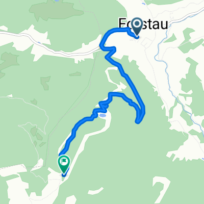
Forstau - Oberhüttensee
A cycling route starting in Forstau, Salzburg, Austria.
Overview
About this route
- -:--
- Duration
- 14.9 km
- Distance
- 986 m
- Ascent
- 13 m
- Descent
- ---
- Avg. speed
- ---
- Max. altitude

Continue with Bikemap
Use, edit, or download this cycling route
You would like to ride Forstau - Oberhüttensee or customize it for your own trip? Here is what you can do with this Bikemap route:
Free features
- Save this route as favorite or in collections
- Copy & plan your own version of this route
- Sync your route with Garmin or Wahoo
Premium features
Free trial for 3 days, or one-time payment. More about Bikemap Premium.
- Navigate this route on iOS & Android
- Export a GPX / KML file of this route
- Create your custom printout (try it for free)
- Download this route for offline navigation
Discover more Premium features.
Get Bikemap PremiumFrom our community
Other popular routes starting in Forstau
 Nova trasa 2.den
- Distance
- 53.2 km
- Ascent
- 296 m
- Descent
- 275 m
- Location
- Forstau, Salzburg, Austria
 001-Radstadt-St.Michael
- Distance
- 54.2 km
- Ascent
- 1,665 m
- Descent
- 1,449 m
- Location
- Forstau, Salzburg, Austria
 Gleiming Ramsau
- Distance
- 38.3 km
- Ascent
- 736 m
- Descent
- 737 m
- Location
- Forstau, Salzburg, Austria
 Gleiming Obertauern
- Distance
- 66.5 km
- Ascent
- 1,036 m
- Descent
- 1,036 m
- Location
- Forstau, Salzburg, Austria
 4 Flüsse
- Distance
- 69.7 km
- Ascent
- 441 m
- Descent
- 607 m
- Location
- Forstau, Salzburg, Austria
 Forstau nach Fagerstraße, Forstau
- Distance
- 5.5 km
- Ascent
- 687 m
- Descent
- 70 m
- Location
- Forstau, Salzburg, Austria
 Gleiming 2, Schladming to Gleiming 2, Schladming
- Distance
- 29 km
- Ascent
- 555 m
- Descent
- 1,163 m
- Location
- Forstau, Salzburg, Austria
 STONEMAN_TAG_2
- Distance
- 60.1 km
- Ascent
- 1,969 m
- Descent
- 1,963 m
- Location
- Forstau, Salzburg, Austria
Open it in the app