

Livigno - Tunnel - Ofenpaß - Scoul (mittel)
A cycling route starting in Livigno, Lombardy, Italy.
Overview
About this route
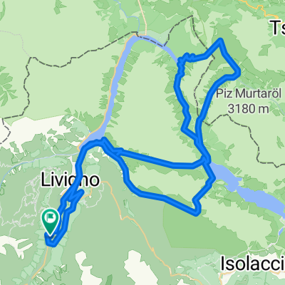
Die Tour startet von Livigno Richtung Norden am Lago di Livigno entlang bis zur Staumauer. Von dort aus geht es dann mit einem Bike-Taxi durch den Tunnel in die Schweiz. In der Schweiz angekommen fährt man dann weiter auf dem Bike Richtung Osten auf der Strasse bis zum Ofenpaß. Nach dem man den Ofenpaß bei ca 2150m überquert hat geht es nach ca. 400m rechts ab auf einem Forstweg zur "Alp da Munt". Hinter der Alp muss man dann gleich wieder rechts hoch abbiegen Richtung S-charl. Der Weg ist zu Anfang auch noch sehr gut fahrbar, verliert sich aber im Verlauf zu einem Single-Trail. Unterwegs kann man immer wieder Bekanntschaft mit den ortsansässigen Murmeltieren machen (das Pfeifen ist so leit, dass man fast vom Bike fällt). Nachdem man den Paß in eine Höhe von 2393m überquert hat geht es auf einem Single-Trail bis zur "Alp Astras". Dort angekommen fährt man nun weiter auf einem landschaftlich sehr schönen Forstweg immer bergab bis S-charl. Von S-charl fährt man weiter, zu Anfangs auf einer Naturstrasse, später auf Teer, runter bis nach Scuol. Kurz vor Scoul geht es dann links ab Richtung Tennis-Plätze, dort vorbei über die Hängebrücke über den Inn in die City von Scoul.
Fazit: Eine landschaftlich sehr schöne und abwechslungsreiche Strecke mit einigen Höhenmetern und einer super tollen Abfahrt nach Scuol.
- -:--
- Duration
- 53.4 km
- Distance
- 1,139 m
- Ascent
- 1,665 m
- Descent
- ---
- Avg. speed
- ---
- Max. altitude
Continue with Bikemap
Use, edit, or download this cycling route
You would like to ride Livigno - Tunnel - Ofenpaß - Scoul (mittel) or customize it for your own trip? Here is what you can do with this Bikemap route:
Free features
- Save this route as favorite or in collections
- Copy & plan your own version of this route
- Sync your route with Garmin or Wahoo
Premium features
Free trial for 3 days, or one-time payment. More about Bikemap Premium.
- Navigate this route on iOS & Android
- Export a GPX / KML file of this route
- Create your custom printout (try it for free)
- Download this route for offline navigation
Discover more Premium features.
Get Bikemap PremiumFrom our community
Other popular routes starting in Livigno
 Giro delle tee
- Distance
- 22.3 km
- Ascent
- 384 m
- Descent
- 386 m
- Location
- Livigno, Lombardy, Italy
 Alpisella Val Tort
- Distance
- 35.9 km
- Ascent
- 989 m
- Descent
- 989 m
- Location
- Livigno, Lombardy, Italy
 Livigno - Mottolino Flow Trail
- Distance
- 25 km
- Ascent
- 823 m
- Descent
- 823 m
- Location
- Livigno, Lombardy, Italy
 Passo Di Vale Alpisella
- Distance
- 8.3 km
- Ascent
- 555 m
- Descent
- 675 m
- Location
- Livigno, Lombardy, Italy
 Livigno camp - Pass Forcola di Livigno - Pass da Val Viola - Passo della Vallacia - Passo d`Eira - singl do Val delle Mine
- Distance
- 63.7 km
- Ascent
- 2,061 m
- Descent
- 2,079 m
- Location
- Livigno, Lombardy, Italy
 Val federia 25 Agosto
- Distance
- 14.4 km
- Ascent
- 438 m
- Descent
- 438 m
- Location
- Livigno, Lombardy, Italy
 livigno stelvio
- Distance
- 54.9 km
- Ascent
- 2,108 m
- Descent
- 1,178 m
- Location
- Livigno, Lombardy, Italy
 Livigno - Passo del Gallo
- Distance
- 65.7 km
- Ascent
- 1,621 m
- Descent
- 1,621 m
- Location
- Livigno, Lombardy, Italy
Open it in the app