

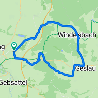
Rothenburg-Creglingen
A cycling route starting in Rothenburg upon Tauber, Bavaria, Germany.
Overview
About this route
Start am Parkplatz Bronnenmühle, wegen der langen Abfahrt von Lindel nach Creglingen empfiiehlt sich diese Richtung, eine Einkehr in Creglingen lohnt sich. Die Strecke entlang der Tauber geht ziemlich auf und ab.
- -:--
- Duration
- 39.8 km
- Distance
- 324 m
- Ascent
- 324 m
- Descent
- ---
- Avg. speed
- ---
- Max. altitude
Route photos


Route quality
Waytypes & surfaces along the route
Waytypes
Quiet road
15.4 km
(39 %)
Track
12.6 km
(32 %)
Surfaces
Paved
31.8 km
(80 %)
Asphalt
30.4 km
(76 %)
Paved (undefined)
0.8 km
(2 %)
Continue with Bikemap
Use, edit, or download this cycling route
You would like to ride Rothenburg-Creglingen or customize it for your own trip? Here is what you can do with this Bikemap route:
Free features
- Save this route as favorite or in collections
- Copy & plan your own version of this route
- Sync your route with Garmin or Wahoo
Premium features
Free trial for 3 days, or one-time payment. More about Bikemap Premium.
- Navigate this route on iOS & Android
- Export a GPX / KML file of this route
- Create your custom printout (try it for free)
- Download this route for offline navigation
Discover more Premium features.
Get Bikemap PremiumFrom our community
Other popular routes starting in Rothenburg upon Tauber
 Frankenhöhe
- Distance
- 25 km
- Ascent
- 219 m
- Descent
- 224 m
- Location
- Rothenburg upon Tauber, Bavaria, Germany
 Taubertal-Panorama
- Distance
- 52.4 km
- Ascent
- 733 m
- Descent
- 895 m
- Location
- Rothenburg upon Tauber, Bavaria, Germany
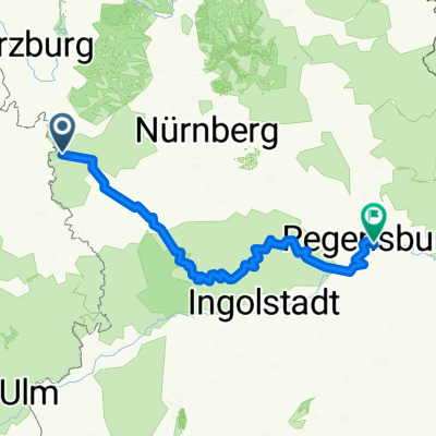 Rothenburg-Regensburg
- Distance
- 263.4 km
- Ascent
- 1,292 m
- Descent
- 1,373 m
- Location
- Rothenburg upon Tauber, Bavaria, Germany
 Rund um Rothenburg
- Distance
- 23.1 km
- Ascent
- 463 m
- Descent
- 445 m
- Location
- Rothenburg upon Tauber, Bavaria, Germany
 Altmühlradweg: Rothenburg-Kelheim
- Distance
- 244.8 km
- Ascent
- 316 m
- Descent
- 400 m
- Location
- Rothenburg upon Tauber, Bavaria, Germany
 Route zu Kaufland
- Distance
- 2.6 km
- Ascent
- 115 m
- Descent
- 24 m
- Location
- Rothenburg upon Tauber, Bavaria, Germany
 Rothenburg to Bamberg
- Distance
- 120.8 km
- Ascent
- 98 m
- Descent
- 285 m
- Location
- Rothenburg upon Tauber, Bavaria, Germany
 Rothenburg-Tauberquelle
- Distance
- 44.7 km
- Ascent
- 278 m
- Descent
- 278 m
- Location
- Rothenburg upon Tauber, Bavaria, Germany
Open it in the app