

Thursday, June 25th @ 3:30pm
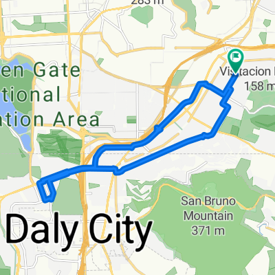
A cycling route starting in Daly City, California, United States.
Overview
About this route
- -:--
- Duration
- 33.9 km
- Distance
- 366 m
- Ascent
- 366 m
- Descent
- ---
- Avg. speed
- ---
- Max. altitude

Route quality
Waytypes & surfaces along the route
Waytypes
Busy road
10.1 km
(30 %)
Quiet road
9.1 km
(27 %)
Surfaces
Paved
16.8 km
(50 %)
Asphalt
16.6 km
(49 %)
Concrete
0.2 km
(<1 %)
Undefined
17.1 km
(50 %)
Route highlights
Points of interest along the route
Point of interest after 7.4 km
Boat House
Point of interest after 12.7 km
Ocean Beach
Point of interest after 28.7 km
Sub Center
Continue with Bikemap
Use, edit, or download this cycling route
You would like to ride Thursday, June 25th @ 3:30pm or customize it for your own trip? Here is what you can do with this Bikemap route:
Free features
- Save this route as favorite or in collections
- Copy & plan your own version of this route
- Sync your route with Garmin or Wahoo
Premium features
Free trial for 3 days, or one-time payment. More about Bikemap Premium.
- Navigate this route on iOS & Android
- Export a GPX / KML file of this route
- Create your custom printout (try it for free)
- Download this route for offline navigation
Discover more Premium features.
Get Bikemap PremiumFrom our community
Other popular routes starting in Daly City
 San Francisco Saturday loop #1
- Distance
- 38.3 km
- Ascent
- 432 m
- Descent
- 433 m
- Location
- Daly City, California, United States
 San Bruno mt loop
- Distance
- 30.3 km
- Ascent
- 546 m
- Descent
- 546 m
- Location
- Daly City, California, United States
 Thursday, June 25th @ 3:30pm
- Distance
- 33.9 km
- Ascent
- 366 m
- Descent
- 366 m
- Location
- Daly City, California, United States
 Route 1 Loop
- Distance
- 17.1 km
- Ascent
- 135 m
- Descent
- 137 m
- Location
- Daly City, California, United States
 San Francisco
- Distance
- 15.2 km
- Ascent
- 384 m
- Descent
- 384 m
- Location
- Daly City, California, United States
 Daly City Westlake Mall via Cayuga/Alemany
- Distance
- 14 km
- Ascent
- 180 m
- Descent
- 182 m
- Location
- Daly City, California, United States
 April 2, 2020
- Distance
- 18.3 km
- Ascent
- 174 m
- Descent
- 174 m
- Location
- Daly City, California, United States
 Lake Merced Sunday
- Distance
- 10.9 km
- Ascent
- 80 m
- Descent
- 79 m
- Location
- Daly City, California, United States
Open it in the app