
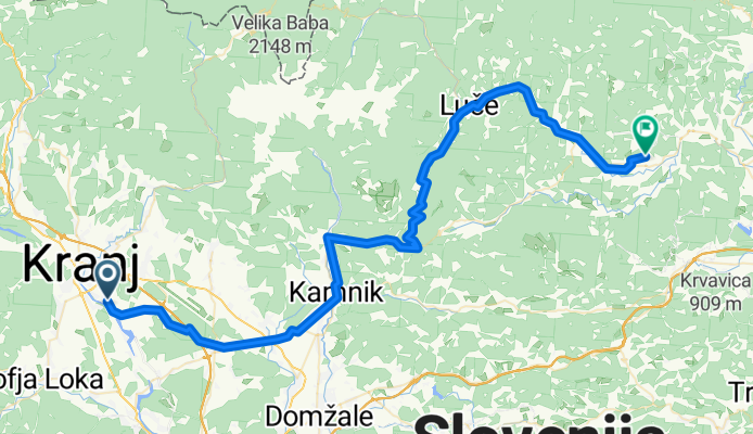
Kranj - Rečica ob Savinji
A cycling route starting in Hrastje, Občina Šenčur, Slovenia.
Overview
About this route
Kranj-kamnik-Stahoviva Podvolovljek-Luče-Rečica ob Savinji
- -:--
- Duration
- 73.5 km
- Distance
- 707 m
- Ascent
- 719 m
- Descent
- ---
- Avg. speed
- ---
- Max. altitude

Route quality
Waytypes & surfaces along the route
Waytypes
Quiet road
23.5 km
(32 %)
Road
22.1 km
(30 %)
Surfaces
Paved
53 km
(72 %)
Unpaved
1.5 km
(2 %)
Asphalt
49.3 km
(67 %)
Paved (undefined)
3.7 km
(5 %)
Continue with Bikemap
Use, edit, or download this cycling route
You would like to ride Kranj - Rečica ob Savinji or customize it for your own trip? Here is what you can do with this Bikemap route:
Free features
- Save this route as favorite or in collections
- Copy & plan your own version of this route
- Sync your route with Garmin or Wahoo
Premium features
Free trial for 3 days, or one-time payment. More about Bikemap Premium.
- Navigate this route on iOS & Android
- Export a GPX / KML file of this route
- Create your custom printout (try it for free)
- Download this route for offline navigation
Discover more Premium features.
Get Bikemap PremiumFrom our community
Other popular routes starting in Hrastje
 KRANJ - SLOVENJ GRADEC
- Distance
- 110.2 km
- Ascent
- 1,108 m
- Descent
- 1,073 m
- Location
- Hrastje, Občina Šenčur, Slovenia
 Trboje-Kozina
- Distance
- 108.4 km
- Ascent
- 1,165 m
- Descent
- 1,004 m
- Location
- Hrastje, Občina Šenčur, Slovenia
 2x v klanc v2
- Distance
- 61.7 km
- Ascent
- 872 m
- Descent
- 874 m
- Location
- Hrastje, Občina Šenčur, Slovenia
 Kranj-Zelezniki-Sorica-Bohinj-Bled-Kranj
- Distance
- 119.2 km
- Ascent
- 1,099 m
- Descent
- 1,099 m
- Location
- Hrastje, Občina Šenčur, Slovenia
 Trboje - Petrovo brdo - sorica - Bled - Trboje
- Distance
- 129.4 km
- Ascent
- 1,170 m
- Descent
- 1,172 m
- Location
- Hrastje, Občina Šenčur, Slovenia
 Kranj - Rečica ob Savinji
- Distance
- 73.5 km
- Ascent
- 707 m
- Descent
- 719 m
- Location
- Hrastje, Občina Šenčur, Slovenia
 ena mal naokrog krajša
- Distance
- 66.1 km
- Ascent
- 391 m
- Descent
- 391 m
- Location
- Hrastje, Občina Šenčur, Slovenia
 Kranj-Kr.Gora-Kranj
- Distance
- 146.3 km
- Ascent
- 995 m
- Descent
- 1,001 m
- Location
- Hrastje, Občina Šenčur, Slovenia
Open it in the app