

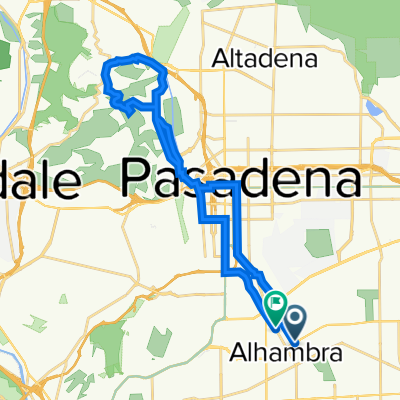
Around the mountain
A cycling route starting in Alhambra, California, United States.
Overview
About this route
- -:--
- Duration
- 30.1 km
- Distance
- 377 m
- Ascent
- 365 m
- Descent
- ---
- Avg. speed
- ---
- Max. altitude
Route quality
Waytypes & surfaces along the route
Waytypes
Road
13.5 km
(45 %)
Busy road
8.8 km
(29 %)
Surfaces
Paved
3.1 km
(10 %)
Asphalt
2.8 km
(9 %)
Paved (undefined)
0.3 km
(1 %)
Undefined
27 km
(90 %)
Continue with Bikemap
Use, edit, or download this cycling route
You would like to ride Around the mountain or customize it for your own trip? Here is what you can do with this Bikemap route:
Free features
- Save this route as favorite or in collections
- Copy & plan your own version of this route
- Sync your route with Garmin or Wahoo
Premium features
Free trial for 3 days, or one-time payment. More about Bikemap Premium.
- Navigate this route on iOS & Android
- Export a GPX / KML file of this route
- Create your custom printout (try it for free)
- Download this route for offline navigation
Discover more Premium features.
Get Bikemap PremiumFrom our community
Other popular routes starting in Alhambra
 Cycling Alhambra to Arroyo Seco
- Distance
- 25 km
- Ascent
- 393 m
- Descent
- 392 m
- Location
- Alhambra, California, United States
 Around the mountain
- Distance
- 30.1 km
- Ascent
- 377 m
- Descent
- 365 m
- Location
- Alhambra, California, United States
 408 W Main St, Alhambra to 900 S Almansor St, Alhambra
- Distance
- 3.5 km
- Ascent
- 0 m
- Descent
- 27 m
- Location
- Alhambra, California, United States
 717 Winthrop Dr, Alhambra to 717 Winthrop Dr, Alhambra
- Distance
- 19.3 km
- Ascent
- 122 m
- Descent
- 130 m
- Location
- Alhambra, California, United States
 Home to Arroyo Park
- Distance
- 9.2 km
- Ascent
- 108 m
- Descent
- 32 m
- Location
- Alhambra, California, United States
 Sunday Morning Ride - 35M
- Distance
- 56.4 km
- Ascent
- 753 m
- Descent
- 751 m
- Location
- Alhambra, California, United States
 South 6th Street 212, Alhambra to South 6th Street 212, Alhambra
- Distance
- 21.7 km
- Ascent
- 172 m
- Descent
- 166 m
- Location
- Alhambra, California, United States
 401 Corto St, Alhambra to 323 San Marcos St, San Gabriel
- Distance
- 3.2 km
- Ascent
- 16 m
- Descent
- 20 m
- Location
- Alhambra, California, United States
Open it in the app