

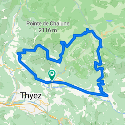
Taninges - Saint-Jeoire - Marignier - Châtillon sur Cluses - Taninges
A cycling route starting in Taninges, Auvergne-Rhône-Alpes, France.
Overview
About this route
For steeper climbing, reverse the route.
- -:--
- Duration
- 27.8 km
- Distance
- 320 m
- Ascent
- 324 m
- Descent
- ---
- Avg. speed
- ---
- Max. altitude
Route quality
Waytypes & surfaces along the route
Waytypes
Quiet road
5 km
(18 %)
Road
4.7 km
(17 %)
Surfaces
Paved
17 km
(61 %)
Unpaved
0.3 km
(1 %)
Asphalt
17 km
(61 %)
Ground
0.3 km
(1 %)
Undefined
10.6 km
(38 %)
Continue with Bikemap
Use, edit, or download this cycling route
You would like to ride Taninges - Saint-Jeoire - Marignier - Châtillon sur Cluses - Taninges or customize it for your own trip? Here is what you can do with this Bikemap route:
Free features
- Save this route as favorite or in collections
- Copy & plan your own version of this route
- Sync your route with Garmin or Wahoo
Premium features
Free trial for 3 days, or one-time payment. More about Bikemap Premium.
- Navigate this route on iOS & Android
- Export a GPX / KML file of this route
- Create your custom printout (try it for free)
- Download this route for offline navigation
Discover more Premium features.
Get Bikemap PremiumFrom our community
Other popular routes starting in Taninges
 Col de la Ramaz is closed
- Distance
- 29.5 km
- Ascent
- 875 m
- Descent
- 875 m
- Location
- Taninges, Auvergne-Rhône-Alpes, France
 Taninges - Col de Joux Plane - Col de Joux Verte - Col de La Ramaz
- Distance
- 116.9 km
- Ascent
- 2,950 m
- Descent
- 2,950 m
- Location
- Taninges, Auvergne-Rhône-Alpes, France
 Joux Plane via alternate route
- Distance
- 48.2 km
- Ascent
- 1,278 m
- Descent
- 1,278 m
- Location
- Taninges, Auvergne-Rhône-Alpes, France
 Franse Alpen stage6
- Distance
- 63.6 km
- Ascent
- 1,126 m
- Descent
- 1,340 m
- Location
- Taninges, Auvergne-Rhône-Alpes, France
 proposta2
- Distance
- 113.8 km
- Ascent
- 2,324 m
- Descent
- 2,325 m
- Location
- Taninges, Auvergne-Rhône-Alpes, France
 Avenue des Thézières 796, Taninges to Route du Bettex 3747, Saint-Gervais-les-Bains
- Distance
- 196.1 km
- Ascent
- 5,577 m
- Descent
- 4,875 m
- Location
- Taninges, Auvergne-Rhône-Alpes, France
 Taninges Mouille rosse
- Distance
- 11.2 km
- Ascent
- 867 m
- Descent
- 23 m
- Location
- Taninges, Auvergne-Rhône-Alpes, France
 Col de Joux Plane / Encrenaz / Ramaz2
- Distance
- 75.4 km
- Ascent
- 2,032 m
- Descent
- 2,032 m
- Location
- Taninges, Auvergne-Rhône-Alpes, France
Open it in the app