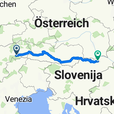
Trentino -- San Candido - Brunico
A cycling route starting in Innichen, Trentino-Alto Adige, Italy.
Overview
About this route
- -:--
- Duration
- 35.4 km
- Distance
- 119 m
- Ascent
- 464 m
- Descent
- ---
- Avg. speed
- ---
- Max. altitude
Route quality
Waytypes & surfaces along the route
Waytypes
Cycleway
9.9 km
(28 %)
Quiet road
7.1 km
(20 %)
Surfaces
Paved
27.3 km
(77 %)
Unpaved
7.8 km
(22 %)
Asphalt
26.9 km
(76 %)
Loose gravel
4.3 km
(12 %)
Continue with Bikemap
Use, edit, or download this cycling route
You would like to ride Trentino -- San Candido - Brunico or customize it for your own trip? Here is what you can do with this Bikemap route:
Free features
- Save this route as favorite or in collections
- Copy & plan your own version of this route
- Sync your route with Garmin or Wahoo
Premium features
Free trial for 3 days, or one-time payment. More about Bikemap Premium.
- Navigate this route on iOS & Android
- Export a GPX / KML file of this route
- Create your custom printout (try it for free)
- Download this route for offline navigation
Discover more Premium features.
Get Bikemap PremiumFrom our community
Other popular routes starting in Innichen
Drava- Distance
- 348.1 km
- Ascent
- 494 m
- Descent
- 1,413 m
- Location
- Innichen, Trentino-Alto Adige, Italy
Drauradweg: Toblach - Maribor- Distance
- 358.8 km
- Ascent
- 358 m
- Descent
- 1,495 m
- Location
- Innichen, Trentino-Alto Adige, Italy
Dolomiti 2022- Distance
- 294.3 km
- Ascent
- 10,887 m
- Descent
- 11,438 m
- Location
- Innichen, Trentino-Alto Adige, Italy
Sankt-Michaels-Platz, Innichen nach Berg, Berg im Drautal- Distance
- 79.2 km
- Ascent
- 767 m
- Descent
- 1,262 m
- Location
- Innichen, Trentino-Alto Adige, Italy
Girolibero: Ciclabile della Drava classica- Distance
- 293.4 km
- Ascent
- 772 m
- Descent
- 1,526 m
- Location
- Innichen, Trentino-Alto Adige, Italy
Pflegplatz, Innichen nach Ulica kralja Tomislava, Krk- Distance
- 391.5 km
- Ascent
- 6,969 m
- Descent
- 8,134 m
- Location
- Innichen, Trentino-Alto Adige, Italy
Recording from 9 Gennaio 12:53 PM- Distance
- 7.7 km
- Ascent
- 219 m
- Descent
- 271 m
- Location
- Innichen, Trentino-Alto Adige, Italy
CEGT2025 - Tappa 1 - da San Candido a Lienz- Distance
- 44.2 km
- Ascent
- 422 m
- Descent
- 918 m
- Location
- Innichen, Trentino-Alto Adige, Italy
Open it in the app


