

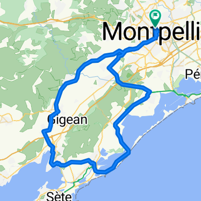
Rue Le Pérugin 145, Montpellier to Rue Le Pérugin 145, Montpellier
A cycling route starting in Montpellier, Occitanie, France.
Overview
About this route
- 4 h 33 min
- Duration
- 89.2 km
- Distance
- 781 m
- Ascent
- 781 m
- Descent
- 19.6 km/h
- Avg. speed
- ---
- Max. altitude

Route quality
Waytypes & surfaces along the route
Waytypes
Road
21.4 km
(24 %)
Cycleway
8.9 km
(10 %)
Surfaces
Paved
44.6 km
(50 %)
Asphalt
41 km
(46 %)
Paved (undefined)
1.8 km
(2 %)
Continue with Bikemap
Use, edit, or download this cycling route
You would like to ride Rue Le Pérugin 145, Montpellier to Rue Le Pérugin 145, Montpellier or customize it for your own trip? Here is what you can do with this Bikemap route:
Free features
- Save this route as favorite or in collections
- Copy & plan your own version of this route
- Split it into stages to create a multi-day tour
- Sync your route with Garmin or Wahoo
Premium features
Free trial for 3 days, or one-time payment. More about Bikemap Premium.
- Navigate this route on iOS & Android
- Export a GPX / KML file of this route
- Create your custom printout (try it for free)
- Download this route for offline navigation
Discover more Premium features.
Get Bikemap PremiumFrom our community
Other popular routes starting in Montpellier
 Tour de France 2009, Etappe 4 - 30,0 km
- Distance
- 39 km
- Ascent
- 372 m
- Descent
- 367 m
- Location
- Montpellier, Occitanie, France
 Boulevard de Strasbourg 27, Montpellier to Plan du Sesquier 4, Mèze
- Distance
- 41.2 km
- Ascent
- 242 m
- Descent
- 262 m
- Location
- Montpellier, Occitanie, France
 De Rue du Roc de Pézenas 26, Montpellier à Castries
- Distance
- 24 km
- Ascent
- 28 m
- Descent
- 26 m
- Location
- Montpellier, Occitanie, France
 To_Barcelona
- Distance
- 404.5 km
- Ascent
- 652 m
- Descent
- 659 m
- Location
- Montpellier, Occitanie, France
 OPT9_montpelliers_cerbere
- Distance
- 233 km
- Ascent
- 217 m
- Descent
- 260 m
- Location
- Montpellier, Occitanie, France
 Première sortie (12/09)
- Distance
- 15.3 km
- Ascent
- 126 m
- Descent
- 125 m
- Location
- Montpellier, Occitanie, France
 Weekend trip - Montpellier - Valflaunes - Vallée de la Bueges
- Distance
- 131 km
- Ascent
- 1,128 m
- Descent
- 1,127 m
- Location
- Montpellier, Occitanie, France
 LUNDI 11 NOVEMBRE : MUC Montpellier - RDV CREPS 8h30 90km Point café à Cournonterral par le club du Guidon Sportif Sétois
- Distance
- 75 km
- Ascent
- 236 m
- Descent
- 236 m
- Location
- Montpellier, Occitanie, France
Open it in the app