

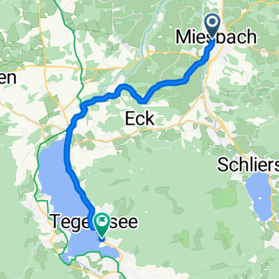
Leitzach, Mangfall, Inn
A cycling route starting in Miesbach, Bavaria, Germany.
Overview
About this route
- 5 h 12 min
- Duration
- 86.2 km
- Distance
- 674 m
- Ascent
- 790 m
- Descent
- 16.6 km/h
- Avg. speed
- ---
- Max. altitude

Continue with Bikemap
Use, edit, or download this cycling route
You would like to ride Leitzach, Mangfall, Inn or customize it for your own trip? Here is what you can do with this Bikemap route:
Free features
- Save this route as favorite or in collections
- Copy & plan your own version of this route
- Split it into stages to create a multi-day tour
- Sync your route with Garmin or Wahoo
Premium features
Free trial for 3 days, or one-time payment. More about Bikemap Premium.
- Navigate this route on iOS & Android
- Export a GPX / KML file of this route
- Create your custom printout (try it for free)
- Download this route for offline navigation
Discover more Premium features.
Get Bikemap PremiumFrom our community
Other popular routes starting in Miesbach
 Marienplatz nach Überfahrtweg
- Distance
- 17.2 km
- Ascent
- 195 m
- Descent
- 187 m
- Location
- Miesbach, Bavaria, Germany
 Miesbach - Aueralm
- Distance
- 59.6 km
- Ascent
- 1,209 m
- Descent
- 1,177 m
- Location
- Miesbach, Bavaria, Germany
 AlpenX (Alpenbiber) 2010
- Distance
- 326.4 km
- Ascent
- 5,008 m
- Descent
- 5,108 m
- Location
- Miesbach, Bavaria, Germany
 Leitzach, Mangfall, Inn
- Distance
- 86.2 km
- Ascent
- 674 m
- Descent
- 790 m
- Location
- Miesbach, Bavaria, Germany
 Miesbach - Schliersee - Fischbachau Tour1
- Distance
- 36.4 km
- Ascent
- 300 m
- Descent
- 294 m
- Location
- Miesbach, Bavaria, Germany
 Miesbach Tegernsee Miesbach
- Distance
- 30.7 km
- Ascent
- 264 m
- Descent
- 263 m
- Location
- Miesbach, Bavaria, Germany
 Stadelbergrunde
- Distance
- 14.4 km
- Ascent
- 283 m
- Descent
- 283 m
- Location
- Miesbach, Bavaria, Germany
 20150328_Miesbach-Gmund-Schliersee
- Distance
- 54.1 km
- Ascent
- 593 m
- Descent
- 593 m
- Location
- Miesbach, Bavaria, Germany
Open it in the app