
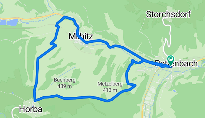
Rottenbach-Milbitz-Horba-Buchberg u. zurück
A cycling route starting in Rottenbach, Free State of Thuringia, Germany.
Overview
About this route
Rundfahrt mit Steigung, herrlicher Aussicht über die Höhen des Thüringer Waldes und ins Rinnetal - viel Natur! Bei Bedarf Einkehr in der Seestadt Horba bzw. am Ende in Rottenbach
- -:--
- Duration
- 8.5 km
- Distance
- 201 m
- Ascent
- 170 m
- Descent
- ---
- Avg. speed
- 452 m
- Max. altitude
Route quality
Waytypes & surfaces along the route
Waytypes
Track
6 km
(71 %)
Busy road
2.2 km
(26 %)
Surfaces
Paved
4 km
(47 %)
Unpaved
2.9 km
(34 %)
Ground
2.5 km
(30 %)
Asphalt
2.3 km
(27 %)
Continue with Bikemap
Use, edit, or download this cycling route
You would like to ride Rottenbach-Milbitz-Horba-Buchberg u. zurück or customize it for your own trip? Here is what you can do with this Bikemap route:
Free features
- Save this route as favorite or in collections
- Copy & plan your own version of this route
- Sync your route with Garmin or Wahoo
Premium features
Free trial for 3 days, or one-time payment. More about Bikemap Premium.
- Navigate this route on iOS & Android
- Export a GPX / KML file of this route
- Create your custom printout (try it for free)
- Download this route for offline navigation
Discover more Premium features.
Get Bikemap PremiumFrom our community
Other popular routes starting in Rottenbach
 Rottenbach-Gösselborn-Singen-Paulinzella u. z.
- Distance
- 22.4 km
- Ascent
- 332 m
- Descent
- 329 m
- Location
- Rottenbach, Free State of Thuringia, Germany
 Leutnitz-Katschen Weichau
- Distance
- 102.8 km
- Ascent
- 350 m
- Descent
- 486 m
- Location
- Rottenbach, Free State of Thuringia, Germany
 Rundfahrt Gemeinde Rottenbach 2011
- Distance
- 27.1 km
- Ascent
- 469 m
- Descent
- 423 m
- Location
- Rottenbach, Free State of Thuringia, Germany
 zum Bäcker nach Bad Blankenburg u. zurück
- Distance
- 8.7 km
- Ascent
- 58 m
- Descent
- 127 m
- Location
- Rottenbach, Free State of Thuringia, Germany
 Gemeinderundfahrt 2012
- Distance
- 25.9 km
- Ascent
- 473 m
- Descent
- 408 m
- Location
- Rottenbach, Free State of Thuringia, Germany
 Rottenbach-Leutnitz-Thälendorf-Solsdorf-Storchsdorf-R.
- Distance
- 15 km
- Ascent
- 228 m
- Descent
- 144 m
- Location
- Rottenbach, Free State of Thuringia, Germany
 Rottenbach-Milbitz-Horba-Buchberg u. zurück
- Distance
- 8.5 km
- Ascent
- 201 m
- Descent
- 170 m
- Location
- Rottenbach, Free State of Thuringia, Germany
 Rottenbach-Köditz-Aschau-Allendorf und zurück
- Distance
- 11.6 km
- Ascent
- 199 m
- Descent
- 199 m
- Location
- Rottenbach, Free State of Thuringia, Germany
Open it in the app