

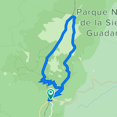
Madrid - Cotos (Alto de Abantos, Puerto de Leones)
A cycling route starting in San Ildefonso, Castille and León, Spain.
Overview
About this route
- -:--
- Duration
- 174.9 km
- Distance
- 1,773 m
- Ascent
- 3,357 m
- Descent
- ---
- Avg. speed
- ---
- Max. altitude

Route highlights
Points of interest along the route
Point of interest after 0.1 km
Cotos 2250m
Point of interest after 1.1 km
Navafria 1800m
Point of interest after 1.9 km
Cabeza del Hierro 1600m
Point of interest after 9.1 km
Puerto de Navacerrada 1900m
Point of interest after 34.2 km
Puerto de Leones1450m
Point of interest after 82.5 km
Puerto de Tornavacas 1200m
Point of interest after 82.5 km
Tras la Serra 1150m
Point of interest after 82.5 km
Arrivée Altitude ? 1950 m
Point of interest after 82.5 km
Puerto del Pico 1400m
Point of interest after 84.1 km
Serranillos 1450m
Point of interest after 84.1 km
Mijajes 1550m
Point of interest after 117.9 km
Alto de Abantos
Continue with Bikemap
Use, edit, or download this cycling route
You would like to ride Madrid - Cotos (Alto de Abantos, Puerto de Leones) or customize it for your own trip? Here is what you can do with this Bikemap route:
Free features
- Save this route as favorite or in collections
- Copy & plan your own version of this route
- Split it into stages to create a multi-day tour
- Sync your route with Garmin or Wahoo
Premium features
Free trial for 3 days, or one-time payment. More about Bikemap Premium.
- Navigate this route on iOS & Android
- Export a GPX / KML file of this route
- Create your custom printout (try it for free)
- Download this route for offline navigation
Discover more Premium features.
Get Bikemap PremiumFrom our community
Other popular routes starting in San Ildefonso
 Peñalara: 5 lagunas-Claveles-2 hermanas
- Distance
- 12.2 km
- Ascent
- 649 m
- Descent
- 653 m
- Location
- San Ildefonso, Castille and León, Spain
 La Granja de San Ildefonso - Talamanca de Jarama
- Distance
- 66.4 km
- Ascent
- 1,182 m
- Descent
- 2,073 m
- Location
- San Ildefonso, Castille and León, Spain
 Cotos - La Granja - Segovia
- Distance
- 31.1 km
- Ascent
- 205 m
- Descent
- 1,019 m
- Location
- San Ildefonso, Castille and León, Spain
 Cerro de la Camorca
- Distance
- 16.3 km
- Ascent
- 979 m
- Descent
- 983 m
- Location
- San Ildefonso, Castille and León, Spain
 Espagne Riaza - Cotos
- Distance
- 168.5 km
- Ascent
- 2,475 m
- Descent
- 3,529 m
- Location
- San Ildefonso, Castille and León, Spain
 Ruta a Camino del Juego de Bolos, 1–7, San Ildefonso
- Distance
- 10.6 km
- Ascent
- 225 m
- Descent
- 765 m
- Location
- San Ildefonso, Castille and León, Spain
 Madrid - Cotos (Alto de Abantos, Puerto de Leones)
- Distance
- 174.9 km
- Ascent
- 1,773 m
- Descent
- 3,357 m
- Location
- San Ildefonso, Castille and León, Spain
 Pradera de Navalhorno - Navalesquilar - Pradera Venta de Araña - Fuente de la Reina - Pradera de Navalhorno
- Distance
- 33.5 km
- Ascent
- 852 m
- Descent
- 852 m
- Location
- San Ildefonso, Castille and León, Spain
Open it in the app