Staffelegg Aufstieg
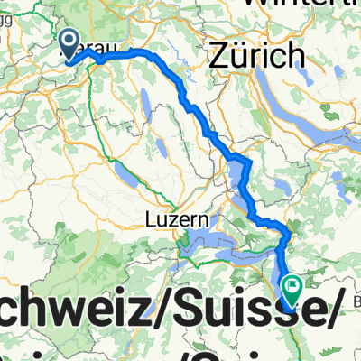
A cycling route starting in Niedergösgen, Canton of Solothurn, Switzerland.
Overview
About this route
Fast descent from the Staffelegg
On the way back, I eventually rode along the Aare.
The path is not exactly worthy of a racing bike.
However, everything can also be done on the road.
- -:--
- Duration
- 36.2 km
- Distance
- 475 m
- Ascent
- 508 m
- Descent
- ---
- Avg. speed
- 659 m
- Max. altitude
Route quality
Waytypes & surfaces along the route
Waytypes
Road
10.5 km
(29 %)
Quiet road
6.9 km
(19 %)
Surfaces
Paved
19.2 km
(53 %)
Unpaved
7.2 km
(20 %)
Asphalt
19.2 km
(53 %)
Gravel
5.1 km
(14 %)
Continue with Bikemap
Use, edit, or download this cycling route
You would like to ride Staffelegg Aufstieg or customize it for your own trip? Here is what you can do with this Bikemap route:
Free features
- Save this route as favorite or in collections
- Copy & plan your own version of this route
- Sync your route with Garmin or Wahoo
Premium features
Free trial for 3 days, or one-time payment. More about Bikemap Premium.
- Navigate this route on iOS & Android
- Export a GPX / KML file of this route
- Create your custom printout (try it for free)
- Download this route for offline navigation
Discover more Premium features.
Get Bikemap PremiumFrom our community
Other popular routes starting in Niedergösgen
Niedergösgen -Lauterbach -Oftringen-- Distance
- 35.4 km
- Ascent
- 476 m
- Descent
- 479 m
- Location
- Niedergösgen, Canton of Solothurn, Switzerland
einfacher Aare Trail- Distance
- 42.8 km
- Ascent
- 71 m
- Descent
- 69 m
- Location
- Niedergösgen, Canton of Solothurn, Switzerland
Gösgen - Gäupassage- Distance
- 40.2 km
- Ascent
- 101 m
- Descent
- 74 m
- Location
- Niedergösgen, Canton of Solothurn, Switzerland
Sempacher See - Kapellenweg LU/ eine "Himmlische Tour"!- Distance
- 115.7 km
- Ascent
- 134,880 m
- Descent
- 134,880 m
- Location
- Niedergösgen, Canton of Solothurn, Switzerland
Niedergösgen /Wasserschloss Niedergösgen 6.12.23- Distance
- 75.2 km
- Ascent
- 503 m
- Descent
- 504 m
- Location
- Niedergösgen, Canton of Solothurn, Switzerland
Mühleweg 4, Niedergösgen nach Alte Stockstrasse 2, Rombach- Distance
- 9.3 km
- Ascent
- 80 m
- Descent
- 92 m
- Location
- Niedergösgen, Canton of Solothurn, Switzerland
Niedergösgen - Rumpel - Niedergösgen- Distance
- 44.9 km
- Ascent
- 669 m
- Descent
- 693 m
- Location
- Niedergösgen, Canton of Solothurn, Switzerland
Langsame Fahrt in Olten- Distance
- 10.8 km
- Ascent
- 184 m
- Descent
- 144 m
- Location
- Niedergösgen, Canton of Solothurn, Switzerland
Open it in the app

