

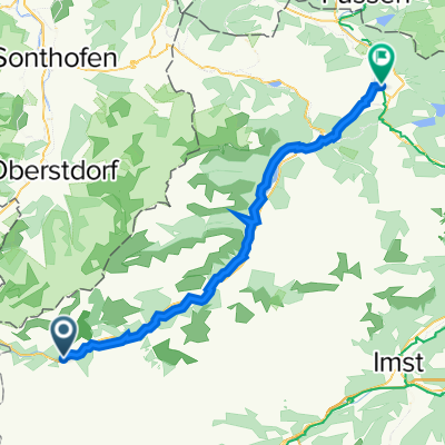
Lechtal Radweg Steeg-Reutte
A cycling route starting in Steeg, Tyrol, Austria.
Overview
About this route
Der bestens ausgeschilderte Lechtal Radweg der Ferienregion Lechtal führt uns durch die unvergleichliche Landschaft der Naturparkregion Lechtal. Der Lechtaler Radwanderweg von Steeg bis Reutte ist eine wunderbare Teiletappe, eingebettet mitten in die Bergwelt der vielgestaltigen Allgäuer- und Lechtaler Alpen. (Tourbeschreibung unter: thod_er@gmx.de)
- -:--
- Duration
- 45.3 km
- Distance
- 12,644 m
- Ascent
- 13,761 m
- Descent
- ---
- Avg. speed
- 1,122 m
- Max. altitude
Route quality
Waytypes & surfaces along the route
Waytypes
Track
32.5 km
(72 %)
Quiet road
7 km
(15 %)
Surfaces
Paved
27.5 km
(61 %)
Unpaved
13.3 km
(29 %)
Asphalt
20 km
(44 %)
Paved (undefined)
7.4 km
(16 %)
Continue with Bikemap
Use, edit, or download this cycling route
You would like to ride Lechtal Radweg Steeg-Reutte or customize it for your own trip? Here is what you can do with this Bikemap route:
Free features
- Save this route as favorite or in collections
- Copy & plan your own version of this route
- Sync your route with Garmin or Wahoo
Premium features
Free trial for 3 days, or one-time payment. More about Bikemap Premium.
- Navigate this route on iOS & Android
- Export a GPX / KML file of this route
- Create your custom printout (try it for free)
- Download this route for offline navigation
Discover more Premium features.
Get Bikemap PremiumFrom our community
Other popular routes starting in Steeg
 Almajurtal-Erlacher Hütte
- Distance
- 31 km
- Ascent
- 857 m
- Descent
- 857 m
- Location
- Steeg, Tyrol, Austria
 Steeg-HolzgauHöhenweg
- Distance
- 14.2 km
- Ascent
- 421 m
- Descent
- 421 m
- Location
- Steeg, Tyrol, Austria
 Steeg-Krabachtal
- Distance
- 10.1 km
- Ascent
- 771 m
- Descent
- 124 m
- Location
- Steeg, Tyrol, Austria
 Lechtal - Inntal
- Distance
- 79.6 km
- Ascent
- 1,737 m
- Descent
- 1,984 m
- Location
- Steeg, Tyrol, Austria
 Steeg 23, Steeg nach Mühler Straße 1, Reutte
- Distance
- 52.7 km
- Ascent
- 420 m
- Descent
- 680 m
- Location
- Steeg, Tyrol, Austria
 Lechtalradweg
- Distance
- 48.9 km
- Ascent
- 92 m
- Descent
- 352 m
- Location
- Steeg, Tyrol, Austria
 Steg - Pflach
- Distance
- 55.1 km
- Ascent
- 24 m
- Descent
- 308 m
- Location
- Steeg, Tyrol, Austria
 Lech Radweg
- Distance
- 225.8 km
- Ascent
- 1,389 m
- Descent
- 2,149 m
- Location
- Steeg, Tyrol, Austria
Open it in the app