

2020 besondere Touren
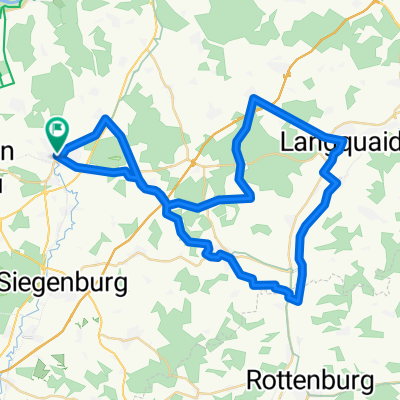
Rück_Abensberg-Offenstetten-Rohr-Niedereulenbach-Rottenburg-Türkenfeld-Hohenthann-Wörth
A cycling route starting in Abensberg, Bavaria, Germany.
Overview
About this route
Die Rückfahrt gestaltete sich viel schöner als die Anfahrt. Diese Route führte über meist abgelegene kleine Ortsverbindungsstraßen mit kaum Verkehr.
- -:--
- Duration
- 53.9 km
- Distance
- 420 m
- Ascent
- 420 m
- Descent
- ---
- Avg. speed
- ---
- Max. altitude

Part of
2020 besondere Touren
8 stages
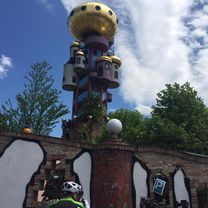
Route photos


Route quality
Waytypes & surfaces along the route
Waytypes
Quiet road
18.5 km
(34 %)
Path
14.9 km
(28 %)
Surfaces
Paved
40 km
(74 %)
Asphalt
40 km
(74 %)
Undefined
13.9 km
(26 %)
Continue with Bikemap
Use, edit, or download this cycling route
You would like to ride Rück_Abensberg-Offenstetten-Rohr-Niedereulenbach-Rottenburg-Türkenfeld-Hohenthann-Wörth or customize it for your own trip? Here is what you can do with this Bikemap route:
Free features
- Save this route as favorite or in collections
- Copy & plan your own version of this route
- Sync your route with Garmin or Wahoo
Premium features
Free trial for 3 days, or one-time payment. More about Bikemap Premium.
- Navigate this route on iOS & Android
- Export a GPX / KML file of this route
- Create your custom printout (try it for free)
- Download this route for offline navigation
Discover more Premium features.
Get Bikemap PremiumFrom our community
Other popular routes starting in Abensberg
 Ho3: Abensberg - Pfaffenhofen a.d. Ilm, 76,6km, 332hm
- Distance
- 76.6 km
- Ascent
- 332 m
- Descent
- 277 m
- Location
- Abensberg, Bavaria, Germany
 Abenstal-Holledau-Tour kurz
- Distance
- 49.7 km
- Ascent
- 475 m
- Descent
- 473 m
- Location
- Abensberg, Bavaria, Germany
 2020-07-11 11:04:26
- Distance
- 133.3 km
- Ascent
- 1,401 m
- Descent
- 1,479 m
- Location
- Abensberg, Bavaria, Germany
 Thementour Stromtreter-Abenstal-Holledau-Tour | Einstieg Bad Gögging
- Distance
- 56.4 km
- Ascent
- 481 m
- Descent
- 492 m
- Location
- Abensberg, Bavaria, Germany
 ABENSBERG KELHEIM
- Distance
- 16.4 km
- Ascent
- 66 m
- Descent
- 82 m
- Location
- Abensberg, Bavaria, Germany
 Abensberg-Saal an der Donau-Riedenburg-Altmannstein-Abensberg
- Distance
- 70.7 km
- Ascent
- 228 m
- Descent
- 225 m
- Location
- Abensberg, Bavaria, Germany
 Prag Tag 2
- Distance
- 103.9 km
- Ascent
- 718 m
- Descent
- 736 m
- Location
- Abensberg, Bavaria, Germany
 Rundtour um Abensberg
- Distance
- 53.2 km
- Ascent
- 438 m
- Descent
- 422 m
- Location
- Abensberg, Bavaria, Germany
Open it in the app