

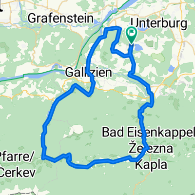
Unternarrach 50 naar Turnersee Campingplatz
A cycling route starting in Gallizien, Carinthia, Austria.
Overview
About this route
- -:--
- Duration
- 56.9 km
- Distance
- 1,179 m
- Ascent
- 1,197 m
- Descent
- ---
- Avg. speed
- ---
- Max. altitude
Route quality
Waytypes & surfaces along the route
Waytypes
Busy road
22.4 km
(39 %)
Road
19.7 km
(35 %)
Surfaces
Paved
36.3 km
(64 %)
Unpaved
0 km
(<1 %)
Asphalt
27.3 km
(48 %)
Paved (undefined)
7.3 km
(13 %)
Continue with Bikemap
Use, edit, or download this cycling route
You would like to ride Unternarrach 50 naar Turnersee Campingplatz or customize it for your own trip? Here is what you can do with this Bikemap route:
Free features
- Save this route as favorite or in collections
- Copy & plan your own version of this route
- Sync your route with Garmin or Wahoo
Premium features
Free trial for 3 days, or one-time payment. More about Bikemap Premium.
- Navigate this route on iOS & Android
- Export a GPX / KML file of this route
- Create your custom printout (try it for free)
- Download this route for offline navigation
Discover more Premium features.
Get Bikemap PremiumFrom our community
Other popular routes starting in Gallizien
 Koschutarunde
- Distance
- 49.3 km
- Ascent
- 640 m
- Descent
- 640 m
- Location
- Gallizien, Carinthia, Austria
 Klopeinské jezero - Klagenfurt a z5
- Distance
- 70.3 km
- Ascent
- 897 m
- Descent
- 897 m
- Location
- Gallizien, Carinthia, Austria
 Po řece Velach
- Distance
- 33.3 km
- Ascent
- 642 m
- Descent
- 627 m
- Location
- Gallizien, Carinthia, Austria
 KäS5: Grafenstein-Velden; 75,2km 360hm
- Distance
- 75.2 km
- Ascent
- 559 m
- Descent
- 508 m
- Location
- Gallizien, Carinthia, Austria
 Unternarrach 50 naar Turnersee Campingplatz
- Distance
- 56.9 km
- Ascent
- 1,179 m
- Descent
- 1,197 m
- Location
- Gallizien, Carinthia, Austria
 Donnerstag 08.07 29KM 160Hm Annabrücke
- Distance
- 28.7 km
- Ascent
- 128 m
- Descent
- 141 m
- Location
- Gallizien, Carinthia, Austria
 Podhorská etapa Jaunstein k lanovce Unterort.
- Distance
- 51 km
- Ascent
- 294 m
- Descent
- 308 m
- Location
- Gallizien, Carinthia, Austria
 Annabrücke Eberndorf Klopeinersee
- Distance
- 36.3 km
- Ascent
- 288 m
- Descent
- 289 m
- Location
- Gallizien, Carinthia, Austria
Open it in the app