

Norskekysten sør til nord etappe 4
A cycling route starting in Trondheim, Sør-Trøndelag Fylke, Norway.
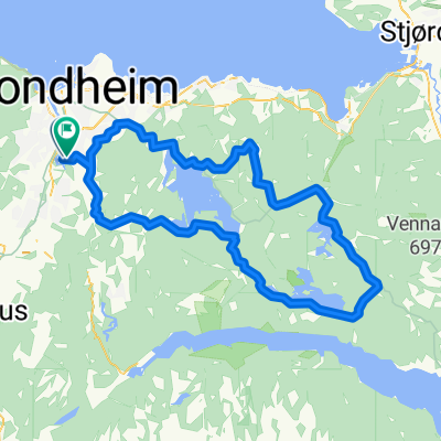
Overview
About this route
DAG 6, 24/7: Horn Ferjekai - Sandnessjøen, 70 km
DAG 5, 23/7: Rundt på Vega
DAG 4, 22/7: Kolvereid til Horn ferjekai, 130 km, ferge til Vega kl 18, 20, 2230, tar 50 min
DAG 3, 21/7: Camping Selnes - Kolvereid, 90 km
DAG 2, 20/7: Langnesodden Camping - Camping Selnes, 140 km
DAG 1, 19/7: Trondheim - Langnesodden Camping, 105 Km. Ferge Flåkk-Rørvik går ca hver halvtime
- -:--
- Duration
- 627.1 km
- Distance
- 987 m
- Ascent
- 998 m
- Descent
- ---
- Avg. speed
- ---
- Max. altitude

Route highlights
Points of interest along the route
Accommodation after 101.3 km
Langnesodden Camping
Accommodation after 222.3 km
Camping Selnes
Accommodation after 306 km
Kolvereid Familiecamping
Accommodation after 523.1 km
Sandnessjøen Camping
Accommodation after 612.4 km
VEGA CAMPING Floa, 8980 Vega Tlf: +47 943 50 080 E-post: post@vegacamping.no Vega Camping på Facebook
Continue with Bikemap
Use, edit, or download this cycling route
You would like to ride Norskekysten sør til nord etappe 4 or customize it for your own trip? Here is what you can do with this Bikemap route:
Free features
- Save this route as favorite or in collections
- Copy & plan your own version of this route
- Split it into stages to create a multi-day tour
- Sync your route with Garmin or Wahoo
Premium features
Free trial for 3 days, or one-time payment. More about Bikemap Premium.
- Navigate this route on iOS & Android
- Export a GPX / KML file of this route
- Create your custom printout (try it for free)
- Download this route for offline navigation
Discover more Premium features.
Get Bikemap PremiumFrom our community
Other popular routes starting in Trondheim

Edge20®
Trondheim Cycling- Distance
- 6.6 km
- Ascent
- 175 m
- Descent
- 174 m
- Location
- Trondheim, Sør-Trøndelag Fylke, Norway
 +100k
+100k- Distance
- 119.9 km
- Ascent
- 634 m
- Descent
- 634 m
- Location
- Trondheim, Sør-Trøndelag Fylke, Norway
 Ranheim-Lade-NTNU
- Distance
- 21.5 km
- Ascent
- 259 m
- Descent
- 361 m
- Location
- Trondheim, Sør-Trøndelag Fylke, Norway
 Jonsvatnet, Foldsjøen, Drakstsjøen
- Distance
- 75.4 km
- Ascent
- 0 m
- Descent
- 0 m
- Location
- Trondheim, Sør-Trøndelag Fylke, Norway
 Trondheim - Bergen via åndalsnes
- Distance
- 994.1 km
- Ascent
- 2,823 m
- Descent
- 2,825 m
- Location
- Trondheim, Sør-Trøndelag Fylke, Norway
 Byneset 1
- Distance
- 56.2 km
- Ascent
- 818 m
- Descent
- 818 m
- Location
- Trondheim, Sør-Trøndelag Fylke, Norway
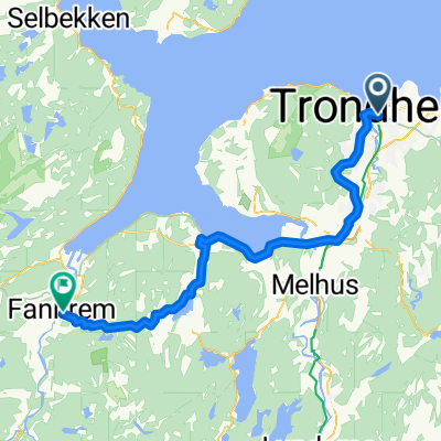 001: Trondheim – Fannrem (PLANNING) - 002: Fannrem – Voll (PLANNING) - 003: Voll – Oppdal (PLANNING) - 004: Oppdal – Hjerkinn (PLANNING) - 005: Hjerkinn – Do...
- Distance
- 53.8 km
- Ascent
- 851 m
- Descent
- 835 m
- Location
- Trondheim, Sør-Trøndelag Fylke, Norway
 Møllenberg-Byneset-Osloveien-Stavne-Møllenberg
- Distance
- 50.3 km
- Ascent
- 574 m
- Descent
- 566 m
- Location
- Trondheim, Sør-Trøndelag Fylke, Norway
Open it in the app