

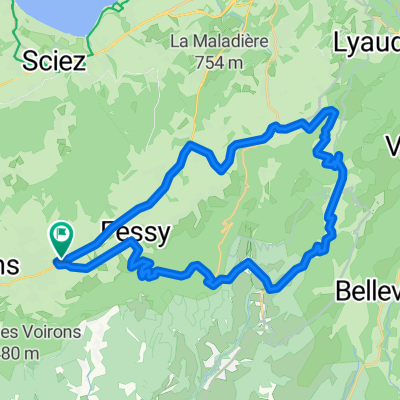
Col de cou
A cycling route starting in Bons-en-Chablais, Auvergne-Rhône-Alpes, France.
Overview
About this route
- -:--
- Duration
- 32.1 km
- Distance
- 762 m
- Ascent
- 762 m
- Descent
- ---
- Avg. speed
- ---
- Max. altitude
Route quality
Waytypes & surfaces along the route
Waytypes
Road
28.4 km
(88 %)
Busy road
2.2 km
(7 %)
Quiet road
1.5 km
(5 %)
Surfaces
Paved
28 km
(87 %)
Asphalt
28 km
(87 %)
Undefined
4.1 km
(13 %)
Continue with Bikemap
Use, edit, or download this cycling route
You would like to ride Col de cou or customize it for your own trip? Here is what you can do with this Bikemap route:
Free features
- Save this route as favorite or in collections
- Copy & plan your own version of this route
- Sync your route with Garmin or Wahoo
Premium features
Free trial for 3 days, or one-time payment. More about Bikemap Premium.
- Navigate this route on iOS & Android
- Export a GPX / KML file of this route
- Create your custom printout (try it for free)
- Download this route for offline navigation
Discover more Premium features.
Get Bikemap PremiumFrom our community
Other popular routes starting in Bons-en-Chablais
 Toor de France Stage 14-17
- Distance
- 286 km
- Ascent
- 24,463 m
- Descent
- 23,289 m
- Location
- Bons-en-Chablais, Auvergne-Rhône-Alpes, France
 Bons-en-Chablais Ramaz
- Distance
- 117.4 km
- Ascent
- 1,941 m
- Descent
- 1,941 m
- Location
- Bons-en-Chablais, Auvergne-Rhône-Alpes, France
 test
test- Distance
- 14.7 km
- Ascent
- 790 m
- Descent
- 19 m
- Location
- Bons-en-Chablais, Auvergne-Rhône-Alpes, France
 frontaliers
- Distance
- 37.9 km
- Ascent
- 280 m
- Descent
- 290 m
- Location
- Bons-en-Chablais, Auvergne-Rhône-Alpes, France
 Col de cou
- Distance
- 32.1 km
- Ascent
- 762 m
- Descent
- 762 m
- Location
- Bons-en-Chablais, Auvergne-Rhône-Alpes, France
 haut chablais
- Distance
- 37.2 km
- Ascent
- 888 m
- Descent
- 885 m
- Location
- Bons-en-Chablais, Auvergne-Rhône-Alpes, France
 Supersaxel-Tête du Char-Col de Cou
- Distance
- 7.4 km
- Ascent
- 292 m
- Descent
- 298 m
- Location
- Bons-en-Chablais, Auvergne-Rhône-Alpes, France
 Tour Vers La Frontiere De Moniaz
- Distance
- 29.8 km
- Ascent
- 299 m
- Descent
- 307 m
- Location
- Bons-en-Chablais, Auvergne-Rhône-Alpes, France
Open it in the app