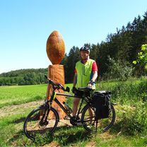
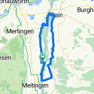
Ellgau-Echsheim-Illdorf-Niederschönenfeld-Oberndorf-Ellgau
A cycling route starting in Ellgau, Bavaria, Germany.
Overview
About this route
Eine sehr schöne abwechslungsreiche Strecke. Start in Ellgau über das Kraftwerk nach Echsheim/ Illdorf und dort weiter bis zum Kraftwerk Niederschönenfeld. Offene Landschaft wie auch bewaldete Strecken wechseln sich ab.
- -:--
- Duration
- 62.3 km
- Distance
- 241 m
- Ascent
- 243 m
- Descent
- ---
- Avg. speed
- ---
- Avg. speed
Route quality
Waytypes & surfaces along the route
Waytypes
Quiet road
26.5 km
(43 %)
Road
16.3 km
(26 %)
Surfaces
Paved
53.4 km
(86 %)
Unpaved
4.6 km
(7 %)
Asphalt
52 km
(84 %)
Gravel
2.9 km
(5 %)
Continue with Bikemap
Use, edit, or download this cycling route
You would like to ride Ellgau-Echsheim-Illdorf-Niederschönenfeld-Oberndorf-Ellgau or customize it for your own trip? Here is what you can do with this Bikemap route:
Free features
- Save this route as favorite or in collections
- Copy & plan your own version of this route
- Sync your route with Garmin or Wahoo
Premium features
Free trial for 3 days, or one-time payment. More about Bikemap Premium.
- Navigate this route on iOS & Android
- Export a GPX / KML file of this route
- Create your custom printout (try it for free)
- Download this route for offline navigation
Discover more Premium features.
Get Bikemap PremiumFrom our community
Other popular routes starting in Ellgau
- Gersthofen
- Distance
- 48.6 km
- Ascent
- 58 m
- Descent
- 58 m
- Location
- Ellgau, Bavaria, Germany
- Ellgau Paffenhofen-Kulturweg-Mertingen Ellgau
- Distance
- 63.8 km
- Ascent
- 72 m
- Descent
- 72 m
- Location
- Ellgau, Bavaria, Germany
- Ellgau-Marxheim-Berdolsheim- Burgheim Rain- Ellgau
- Distance
- 59.5 km
- Ascent
- 60 m
- Descent
- 59 m
- Location
- Ellgau, Bavaria, Germany
- Ellgau
- Distance
- 57.7 km
- Ascent
- 89 m
- Descent
- 85 m
- Location
- Ellgau, Bavaria, Germany
- Ellgau-Echsheim-Illdorf-Niederschönenfeld-Oberndorf-Ellgau
- Distance
- 62.3 km
- Ascent
- 241 m
- Descent
- 243 m
- Location
- Ellgau, Bavaria, Germany
- Ellgau - Buttenwiesen-Tapfheim-Mertingen -Ellgau
- Distance
- 61.8 km
- Ascent
- 82 m
- Descent
- 79 m
- Location
- Ellgau, Bavaria, Germany
- Rain am Lech
- Distance
- 38.7 km
- Ascent
- 50 m
- Descent
- 48 m
- Location
- Ellgau, Bavaria, Germany
- Ellgau-Gersthofen-Mühlhausen- Scherneck-Thierhaupten - Ellgau
- Distance
- 49.9 km
- Ascent
- 223 m
- Descent
- 220 m
- Location
- Ellgau, Bavaria, Germany
Open it in the app